First Alert Weather Day Sunday: Threat of hail, wind, and tornadoes possible
There will be a few sub-severe showers & storms Saturday afternoon. The potential for strong to severe storms is increasing on Sunday & then again Tuesday & Wednesday.
Friday evening will be partly cloudy and mild. Any isolated showers or storms that pop up will diminish, leaving most of North Texas dry overnight. Lows in the mid-60s.
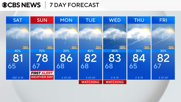
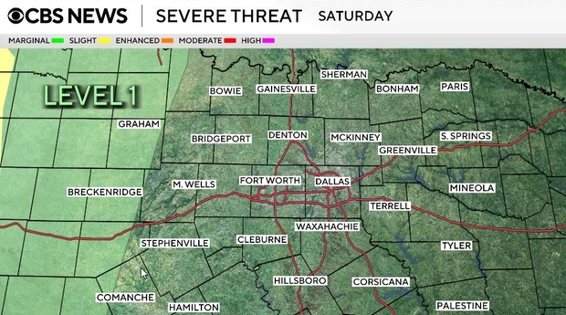
Saturday:
The pattern becomes more active, but the threat of severe weather will remain west of our area. During the morning hours, it will be mostly dry… good news for outdoor plans. By the afternoon, scattered storms will be possible, with higher coverage west of I-35. Highs will be in the low 80s. South-southeast winds 5 to 15 mph, with gusts as high as 25 mph.
During the late evening and overnight hours, storms will develop along a dryline to the west and begin moving toward North Texas. A few storms could be strong, especially across our western counties, with hail and gusty winds. There is still some uncertainty about how well these storms will hold together overnight, but any that do could approach the I-35 corridor by early Sunday morning.
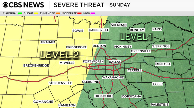
Sunday
This will be our highest-impact day and is a First Alert Weather Day. During the morning hours, we will see lots of clouds, with scattered showers and storms possible. If we can recover and destabilize after the morning activity, strong to severe storms are likely to develop near the dryline during the afternoon and evening. South winds around 15 mph, with gusts as high as 30 mph. Highs will be in the upper 70s to low 80s.
If we get enough sunshine in the afternoon after the first round of storms, instability and wind shear will increase, and storms could produce:
* Large hail
* Damaging winds
* A few tornadoes
There is also a risk for localized flooding in areas that see the heaviest rainfall.
The greatest severe threat will be along and west of I-35, but that could shift depending on how the morning activity evolves.
Monday:
20% chance of additional afternoon and evening storms. Highs in the low 80s. South wind 10 to 15 mph, with gusts as high as 25 mph.
Tuesday - Wednesday
We remain in a southwest flow pattern aloft, keeping daily storm chances of 40% to 50% in the forecast through at least midweek. While periods of stronger storms are possible, confidence in exact timing and coverage remains low this far out.