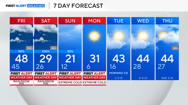
Mild Thursday for North Texas before rain, sleet, snow and extreme cold arrive


All of North Texas is under the first winter storm warning for the season. It starts Friday at 6 p.m. and continues through Sunday at noon.

Cold rain and blustery winds on Friday afternoon will make for difficult travel. We are expecting the biggest rain of winter so far, close to an inch could fall. Temperatures will drop from the upper 40s in the morning down to the lower 40s by the end of the day.
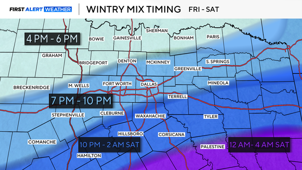
The evening will have a cold rain mixing with freezing rain, changing over to all freezing rain overnight.
This is super-cooled rain that freezes on contact with any surface at freezing or below. It'll take a while, but sometime overnight, we are expecting the roads to start icing over as temperatures drop to the upper 20s. This changeover will start first across Wise, Denton and Collin counties and work its way south.

Saturday, we are getting two rounds of sleet. In the afternoon and evening, some snow and/or freezing rain will be mixed in as well. Most of this will stick to the roads, with 1 to 2 inches of accumulation. All this freezes to hard ice overnight heading into Sunday morning. Some snow is expected to fall, tapering off across Sunday morning from west to east.
Highs on Sunday are only in the low 20s, so road conditions will likely not improve. Overnight, heading into Monday, we drop down to the coldest temperatures since the historic cold spell back in 2021.

Extreme cold warning in place
Wind chills on Sunday and Monday will get below zero at times, especially in the morning hours. This is a dangerous cold, and an extreme cold warning is in place.
We'll have sunshine on Monday, highs will get to about 30 degrees. This will help the roads somewhat, but everything re-freezes overnight.
Roads on Tuesday morning will still have lots of ice. We get into the 40s under partly cloudy skies on Tuesday, the roads should be much better that afternoon and early evening. Everything will re-freeze again on Wednesday morning.
This is the current forecast. This overnight change over Friday night is a big wildcard; the more rain we get, the fewer problems on the roads. Also, we could end up with very little snow by Sunday morning.