Dangerously low wind chills stick around North Texas before weekend warmup

NORTH TEXAS – Dangerous wind chills dropped "feels-like" temperatures to the teens and single digits across North Texas Thursday morning, prompting a First Alert Weather Day.
Across the Dallas-Fort Worth Metroplex, temperatures were sitting in the low to mid-20s and winds held at 10-20 mph.
At 5 a.m., it was 24 degrees at Dallas-Fort Worth International Airport but factoring in the 18 mph winds, the "feels-like" temperature was 10 degrees.
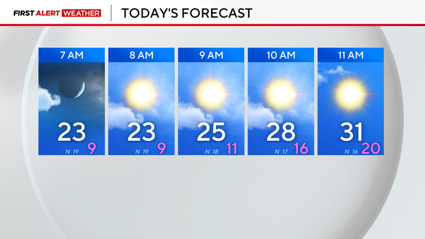
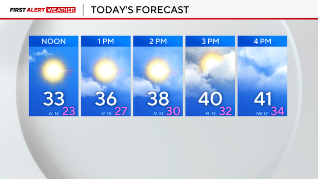
Temperatures will be in the 20s through the morning hours and won't get above freezing until later in the morning. Temperatures could reach the 40s later in the afternoon.
The freezing temperatures caused some patchy ice on Dallas County roads from Wednesday's rain – a portion of northbound I-35E in Oak Cliff was completely shut down at of 5 a.m. due to the ice. Later in the morning, sand trucks were seen treating the roads and the roads reopened by 9 a.m. The patchy ice wasn't widespread – according to the Texas Department of Transportation, there were no reports of icy roads in Fort Worth.
Valentine's Day looks to be warmer with high temperatures in the low 50s but for date night, there is a small chance of some scattered showers. Over the next three days, high temperatures will range from the 40s to 50s to 70s before the next cold front moves in Saturday afternoon, cooling high temperatures back down to the 40s on Sunday.
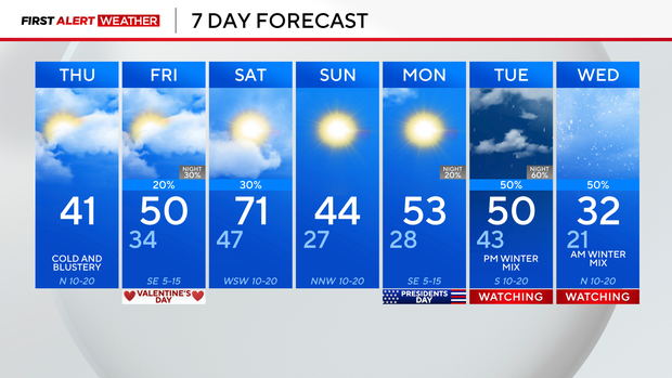
The precipitation on Saturday will shift east before the cold air moves into North Texas and by Monday morning, temperatures will be down into the mid to upper 20s but it will be dry.
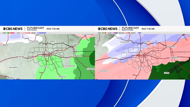
The next big weather change arrives Tuesday into Wednesday morning. CBS News Texas meteorologists are watching the next system closely as there is a mix of cold air and precipitation in play. However, it is too early to land on a definite solution of rain mixing with sleet or snow. The GFS model and the European model aren't in agreement.
Here is late Tuesday afternoon: Both models show precipitation but the European model is much more aggressive with the precipitation coverage.
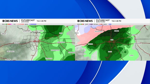
Here is Wednesday morning: The European model shows a mix of rain, sleet and snow while the GFS is much drier with a cold rain in only parts of North Texas.