Rain, storms and flooding risk expected in North Texas as cold front arrives Saturday
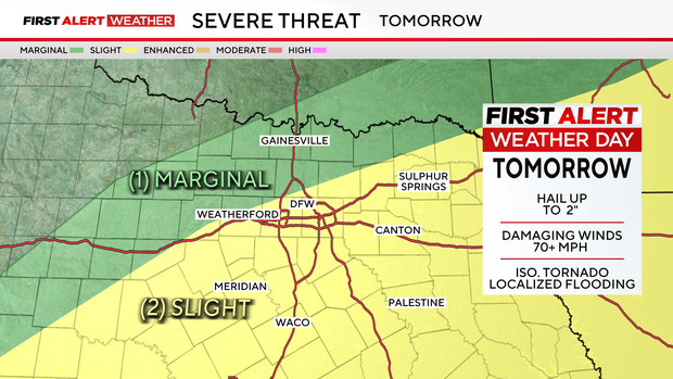
Widespread rain and thunderstorms are expected across North Texas on Saturday as a cold front moves into the region.
The front will arrive Saturday morning, bringing higher chances for showers, storms, and localized flooding. Most of North Texas falls under a level 1 (slight) or level 2 (marginal) severe‑weather risk, with hail and damaging winds the primary threats.
6:30 p.m. - A tornado watch in effect for much of North Texas has been canceled.
The National Weather Service had included 19 counties in the watch, stretching from the Red River to the western edges of the Metroplex. Areas under the alert include Collin, Cooke, Dallas, Denton, Fannin, Grayson, Hopkins, Hunt, Jack, Lamar, Montague, Palo Pinto, Parker, Rockwall, Stephens, Tarrant, Wise, Young, and Delta counties.
Meanwhile, rain totals for Friday through the weekend will likely stay between 1 and 3 inches for most of North Texas, with isolated amounts up to 4 inches or more.
By late Saturday afternoon into Saturday evening, conditions will finally start to dry out.
Sunday looks to be mainly dry for those looking to get outside.
Looking ahead to next week, a few isolated non-severe storms are possible on Monday before the threat of severe weather returns on Tuesday and Wednesday. First Alert Weather Days are in effect for both says due to the level 1 (slight) risk of severe storms.
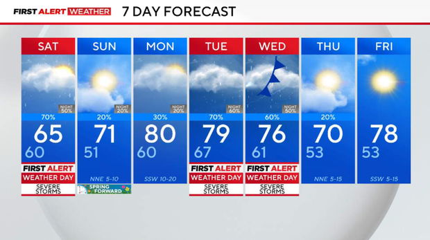
We will finally begin to see a break from severe weather next Thursday.