NOAA's most advanced weather monitoring system will be operational soon
Has anyone noticed some weird/missing data from satellite imagery over the past few weeks? There's a reason for that!
The old satellite that has been used for years is moving, with the most state-of-the-art satellite set to replace it.
Basically, all of the images that are taken from space come from satellites, machines that are launched into space and orbit Earth, or another object and send back information.
The National Oceanic and Atmospheric Administration and NASA collaborated on the sophisticated Geostationary Operational Environmental Satellites, also known as GOES-R Series. Now, for those wondering, what in the world is a Geostationary Operational Environmental Satellite?
It's a satellite that sits above the equator at a speed matching the Earth's rotation, which allows it to constantly view the same area of the Earth at all times.

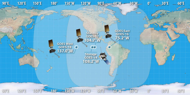
There are four satellites in the GOES-R series, with its coverage spanning from the west coast of Africa to New Zealand and from near the Arctic Circle to the Antarctic Circle — the last of which (GOES-19) will become operational April 7, 2025.
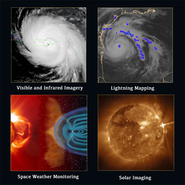
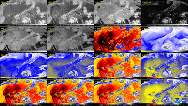
The GOES-R Series imager scans the Earth five times faster with four times the resolution and three times the number of channels than previous satellites for more accurate and reliable forecasts/severe weather warnings. The imager provides images of weather patterns, hurricanes and severe storms as frequently as every 30 seconds.
And there are various other benefits from the GOES-R.
- Hurricane track and intensity forecasts
- Early warning of severe storms and tornadoes
- Fire detection, monitoring, and intensity estimation
- Identification of lightning strikes most likely to ignite fires
- Detection of low clouds and fog
- Monitoring of atmospheric river events that can cause flooding and mudslides
- Monitoring of smoke, dust and aerosols
- Data for air quality warnings and alerts
- Data for aviation route planning and reducing weather-related flight delays
- Detection of volcanic eruptions and monitoring of ash and sulfur dioxide
- Detection of heavy rainfall and flash flood risks.
- Sea surface temperature data for monitoring fisheries and marine life
- Monitoring of vegetative health
- Data for long-term climate variability studies
- Detection of meteors entering Earth's atmosphere
- Detection of coronal holes, solar flares, and coronal mass ejection source regions
- Warning of space weather hazards responsible for communications and navigation disruptions and power blackouts
- Monitoring of energetic particles responsible for radiation hazards
GOES-16 was launched in 2016 and has been operational ever since for the eastern half of the US. GOES-17 was launched in 2018 as an on-orbit backup. GOES-18 was launched in 2022 and now serves as the operational satellite for the western half of the US.
GOES-19 was launched in 2024 and is slated to take over GOES-16 as the main operational satellite for the eastern half of the United States, while GOES-16 becomes the on-orbit backup. During the few weeks it took for GOES-16 and GOES-19 to drift into their new positions, some of the normally flawless satellite images coming from GOES-16 were degraded, which is the reason it looked all wonky/weird earlier.
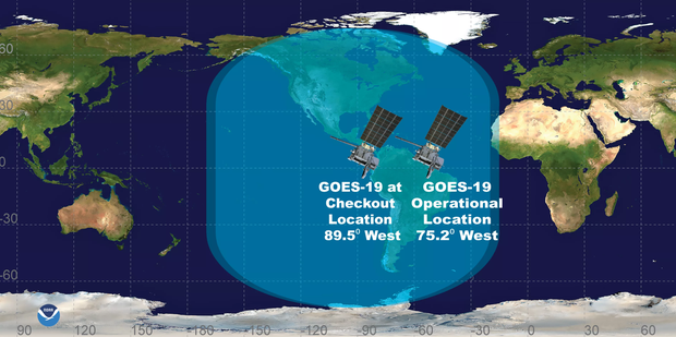
The satellite images will likely no longer be degraded as of Monday when the new GOES-19 satellite officially replaces the old one. But why does this matter?
Satellites are the main source of critical atmospheric, hydrologic, oceanic, climatic, solar and space data. GOES-19 is the culmination of nearly five decades of research, with its primary instrument being the ABI. It's the most advanced weather-observing and environmental monitoring system, providing enhanced imagery and atmospheric measurements, real-time mapping of lightning activity, and space weather observations. The ABI is a tool that can view Earth with sixteen different channels, each measuring energy at different wavelengths along the electromagnetic spectrum to obtain information about Earth's atmosphere, land, and ocean.
There's also a brand new instrument, the Compact Coronagraph-1 (CCOR), which will support NOAA's Space Weather Follow On (SWFO) mission. It will be the nation's first operational coronagraph and will serve as the primary source for information about impending geomagnetic storm conditions, allowing the Space Weather Prediction Center to issue warnings one to four days in advance.
Tools like these significantly improve detection and observation of environmental phenomena that directly affect public safety, protection of property, and our nation's economic health and prosperity.


