When all of Pittsburgh's snow melts, will it lead to flooding? A meteorologist explains.
With all the recent snow and cold temperatures, does that guarantee the Pittsburgh area will experience a lot of flooding this spring?
The short answer is no. The process of snowmelt and the factors that lead to flooding are more complex than they first appear.
First, we must consider preceding conditions. While this winter has been much snowier than normal, soil moisture conditions are lower than normal due to the flash drought that developed last summer and persisted into fall.
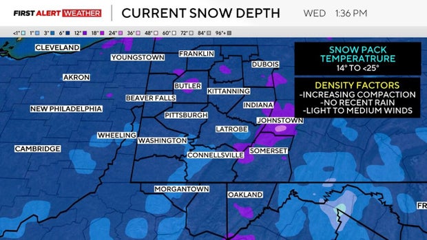
Next, qualities of the snowpack, such as depth, density and temperature, must be considered. Most of the area currently has a snow depth between 6 to 12 inches, with localized higher amounts depending on location. This snowpack, while originally light and fluffy, is slowly starting to become denser thanks to compaction.
However, the area hasn't received any rain since the last big winter storm, so that prevents the snowpack from becoming waterlogged. The air has also been dry, allowing some of the snow to sublimate, meaning a solid undergoes a phase change to a vapor.
The temperature of the snowpack has also remained well below freezing, with data from the National Weather Service indicating the latest snowpack temperature ranges anywhere from 14 degrees to less than 25 degrees. These low temperatures indicate the snowpack is not "ripe," or ready to start melting and running off into area waterways.
Moisture in the air also plays a role as well. When the air is drier, this helps the snowpack to remain colder and cool itself through sublimation, but higher levels of moisture prevent the temperature of the snowpack from staying as low because it cannot sublimate as well.
Lastly, winds and heavy precipitation play a crucial role in the process of snowmelt, runoff and flooding. Higher winds can cause the snowpack to sublimate and redistribute the snowpack. Heavy rain can accelerate runoff by causing snow to become waterlogged, ripen, and melt when most vegetation is still dormant or soil is frozen.
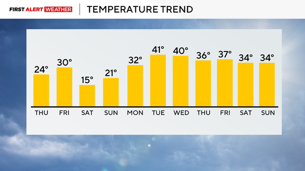
We are anticipating a gradual warming trend to occur by the middle of next week. Temperatures are likely to warm above freezing by mid next week, but at this point, a rapid spike of temperatures (at least through Feb. 15) is not anticipated.
There will be a more active storm track out of the western U.S., which will favor increased precipitation opportunities in the Pittsburgh area.
As long as the area doesn't experience a rapid spike in temperatures or a short-duration heavy rain event, the Upper Ohio Valley will experience gradual snow melt, with any river flooding concerns attributed to ice jams.
The First Alert Weather Team will be monitoring conditions closely in the coming weeks.