Wildfire smoke and poor air quality affecting Pittsburgh today


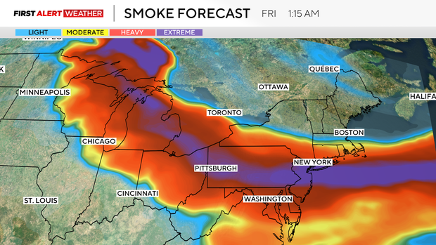
The next two days are First Alert Weather days due to hot weather and air quality. The air quality is expected to be at its worst this evening, overnight, and into Friday afternoon.
Thursday is a Code Red Day issued by the Pennsylvania DEP. This means the air is unhealthy for everyone, and time spent outdoors should be limited. The worst time for the smoke will be overnight, and we could potentially even get into the purple range, where we go up to "very unhealthy."
High temperatures on Thursday will be right at 90 degrees, but the smoke may be thick enough to keep us out of the 90s. It will be close. Morning temperatures dipped to the mid-70s, and noon temperatures will likely already be near 90. Winds will be fairly light coming in from the northwest at 5-10 mph.
What impact does this have on you?
First off, you should do your best to get outdoor activities done early today and plan on indoor activities for all of Friday. Keep windows closed. Limit strenuous activities. Settle in and watch a good movie.
Air quality will improve on Saturday morning, but it will still be a First Alert Weather Day due to storm chances.
While air quality will be better on Saturday, if you have outdoor plans on Saturday, you will be dodging rain and storms all day long.
Saturday will see big gaps in between rain, with storm chances rising with every new wave of storms. Severe weather will more than likely be confined to Saturday evening after 6 p.m.
How to stay safe
Experts have compared two hours of outside exposure to the smoke in the atmosphere to smoking a cigarette, and that creates concern for anyone who may be outside in these conditions.
"It's almost like you're walking in a room full of smoke, and somebody's smoking," said Dr. Tariq Cheema, chief of pulmonary and critical care for Allegheny Health Network. "It's at that level. It's thick. You can smell it."
But Cheema warned that the hot and humid weather in the forecast this week is already threatening enough for people with respiratory illnesses. Add in the smoke, and that creates three factors all at once that make the air quality very unsafe and all the more serious.
"People who have asthma, emphysema, COPD, or any kind of chronic lung disease, for them, this is dangerous," he said.
Cheema said his office received the highest number of calls on Thursday that it had ever received in these types of situations.
"The advice that we are giving our patients is: If you can, stay home," he said. "Stay in the air conditioning, and if you do have to go out, don't spend too much time outside."
Cheema said there are smoke particles in the air small enough that they're getting straight into your lungs, and then irritating the lungs, causing inflammation. That inflammation can cause a myriad of symptoms, including extreme coughing, wheezing, and increased shortness of breath. It also leads to a higher chance of hospitalization.
"Listen to your body," he said. "If you're coughing, if you're irritated from this, come inside."
Since the smoke is expected to leave the area by the end of the weekend, Cheema said he doesn't think people with healthy lungs should worry about any long-term effects, but still advised people to wait until it has left the area to resume normal outdoor activities.