When the wildfire smoke will clear in Pittsburgh, improving air quality

Thick surface-based wildfire smoke that originated in Canada and Northern Minnesota continues to linger across all of western Pennsylvania, eastern Ohio and northern West Virginia as of early Friday afternoon.
However, the area will likely get a break soon.
Conditions to worsen through Friday
For the remainder of Friday into the night, smoke concentrations are expected to increase again as the flow around a surface high pressure to our north and an approaching warm front in central Ohio essentially help to squeeze as much smoke as possible into a narrowly concentrated path across most of the area.
Pennsylvania is under a statewide Code Purple air quality alert, meaning the pollution is considered "very unhealthy." Sensitive groups should avoid all physical activity outdoors, and everyone else should avoid doing anything strenuous outside.
Visibility will remain low, possibly dipping to 1/2 to 1 mile in spots, especially Friday evening.
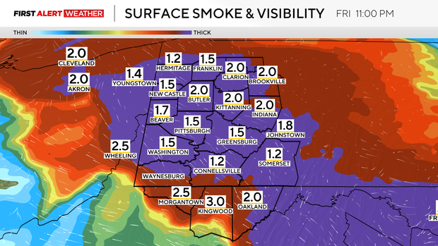
When the smoke begins to move out
Overnight into Saturday morning will remain very smoky across the Pittsburgh region, but we do anticipate clearing from southwest to northeast across our entire forecast area during the predawn hours of Saturday.
By 7 a.m., areas southwest of the Pennsylvania Turnpike and Interstate 70 corridor should notice improvement in air quality. Between 7 a.m. and noon, the surface-based smoke will continue to move northeast, with most of our forecast area in the clear by noon Saturday.
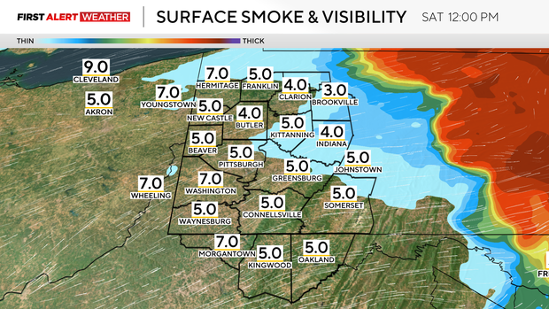
Severe weather follows smoke clearing
While we will see a clearing from the smoke, our next weather hazard will begin to come into play by Saturday afternoon and evening. Scattered strong to severe storms are expected to develop as moisture and unstable air build in advance of an approaching cold front.
Development will occur as early as 1 p.m. to 2 p.m., with the initial storms being isolated to widely scattered. By 5 p.m. to 6 p.m., storms will become more widespread, especially along the Interstate 80 corridor, then move south across the rest of our forecast area from 6 p.m. to 11 p.m.
The main threats with storms on Saturday will be damaging straight line winds, so expect several severe thunderstorm warnings to be issued.
There will be a low tornado risk as well, especially over the northern half of the forecast area where low-level wind shear will be strong enough to allow a couple of storms to rotate. If a tornado did occur, it would most likely be weak and brief.
Smoke returns Sunday
Storms will exit Saturday night after midnight and winds at the ground and aloft will shift to northwest on Sunday, bringing in drier and cooler air. With this shift in wind direction, more wildfire smoke and haze are possible on Sunday.
At this point, it doesn't look like this next round will be as thick as what is occurring Friday. There is still plenty of uncertainty, however, and we likely won't get a better idea until Saturday as to what to expect for Sunday.
It has rained over some of the fire hotspots in Canada and Northern Minnesota as of Friday morning, but it is likely that several spots were missed, and/or the rain wasn't enough to substantially quell the fires.
Monday looks to be dry and pleasant, although there may be a slight haze in the sky.


