Sunny conditions expected today for the Pittsburgh area after passing morning showers

It's going to be a warm and sunny day in the Pittsburgh area following some passing morning rain showers.
Any Alert Days Ahead? Currently no, but that will not be the case by noon. I will likely be firing off First Alerts for some combination of Tuesday, Wednesday, & Thursday due to wind storm chances. The threat will likely remain in place on Friday too, from what data is pointing to.
Aware: Today's rain won't be enough to secure the most rain on record in August crown.
As it stands, today may be our only non-severe weather day of the work week. Currently, there is rain on radar (3 a.m.), with showers expected to be around through 10 a.m. Rain this morning is not heavy, but could slow down parts of your morning routine. I'd give yourself a little extra time heading out the door.
Once the rain gets out of here this morning, expect sunny conditions to break out soon after.
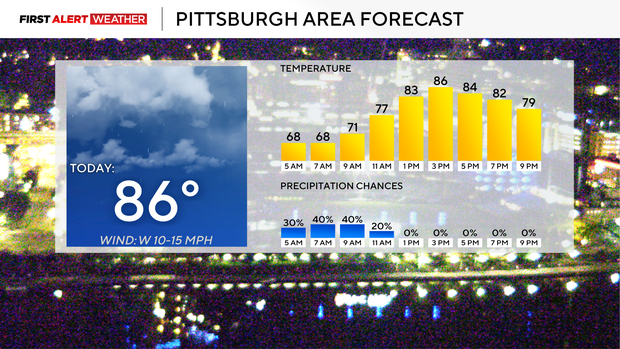
Highs today are expected to soar to the mid-80s, with highs near 90 beginning on Tuesday. I have morning lows today in the mid to upper 60s with light winds coming in from the southwest.
Storm chances on both Tuesday and Thursday don't look widespread, and I will put storm coverage at just 40 percent both days. Any storms that do occur will have a chance to turn into wind storms. These storms will be racing along the jet stream with speeds in excess of 60mph and could potentially knock over trees and cause power outages. Storm chances during the Tuesday through Thursday stretch will be the highest in the afternoons. High temperatures on Tuesday and Thursday will hit the upper 80s. I have Wednesday being the hottest day of the week, and I am going to push the high on Wednesday up to 90 degrees. We average just over one 90-degree day every September, so we may be getting that out of the way early. No surprises there.
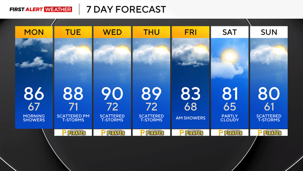
For Labor Day weekend, I have Saturday dry, with rain and storms possible on Sunday. Monday is currently looking dry. Highs over the weekend will be near 80 degrees every day.
It could be a stormy week ahead
We will finish out the month of August with a whimper, with the potential for the first week of September to be roaring.
Right now, the Storm Prediction Center has us shaded as a level one out of five severe risk for Tuesday. They have most of our area shaded as a level 2 out of five storm risk on Wednesday. They also have us shaded for a storm risk on Thursday. Our weather pattern is unusual, as we will have a ridge of high pressure that will push our high temperatures up to near 90 degrees.
The jet stream will also be parked right on top of us, and any shortwave kink will be enough to send strong wind storms our way. With wind storms, there will also be a chance for a quick spin-up or two. This pattern will be in place through at least Friday.


