Fall-like weather returns to the Pittsburgh-area forecast tomorrow

The start of fall is less than a week away, and the weather is going to increasingly feel very fall-like, with more high-temperature days in the 70s than 80s.
Any alert days ahead? Maybe on Sunday due to rain totals. There is a lot of uncertainty on the timing of rain over next week
Aware: Our average high and low really moves this month. On Monday, the average high was 76° and the average low 56°. Today the average high is 75°, and the average low is 54°. The chance for a random hot weather day (85° or higher) is quickly waning.
For today, similar to yesterday, most of the day is going to be dry. There will be periods of mostly sunny skies, but overall today will be mostly cloudy to partly cloudy. I have highs hitting the low 80s with winds of 10-15 mph coming in from the west. Winds will be gusty this afternoon into the evening.
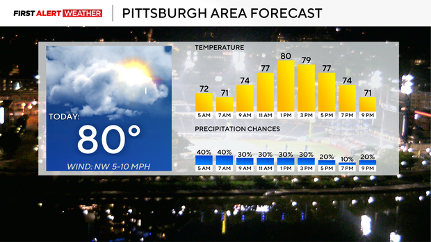
Our highest rain chance will have already passed by the time this is published at 8 a.m., with isolated rain chances possible for the rest of the day.
I have isolated rain chances in place for Friday and Saturday, with highs in the upper 70s and morning lows in the 60s (and upper 50s for some on Saturday).
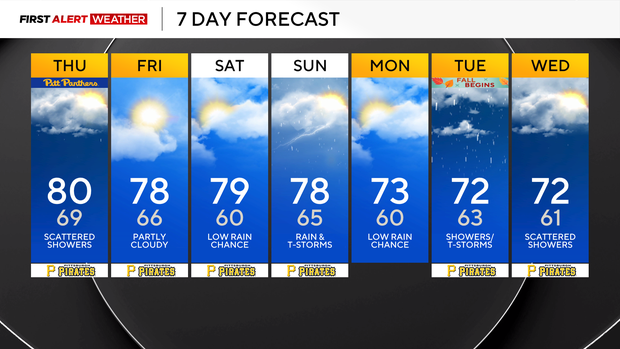
Temperatures will dip again on Monday, with highs in just the low 70s all of next work week. Most days will have a low rain chance, with most of the day looking dry.
Intense heat expected for parts of the country
Now you may have heard about the dome of intense heat that is expected for parts of the East coast and really the deep South over the next couple of days. We are going to be on the edge of the dome, so we will miss out on the heat and see scattered to even widespread storm and rain chances at times. There is some uncertainty when it comes to the timing of rain over the next week. This morning it looks like our highest rain chances will come on Sunday and Tuesday. If you have outside plans or activities happening over the next week, you should really be prepared for rain, as things can certainly change.
While I have our high temperature today hitting 80°, Louisville, Kentucky, is expected to hit 97° for its high. Washington, D.C., is expected to hit 89°. Charlotte, NC, is forecast to hit 92°. Memphis and Dallas may hit 100° today, so the ridge of high pressure is fairly easy to see. Where the ridge ends is where active weather will be possible, and that line stretches right across W. PA for the next few days. The ridge will eventually weaken, with cooler and drier air finally pushing south around Wednesday of next week. This should mean a drier and even cooler pattern starting Wednesday for us going into next weekend.


