Near-record heat lingers in North Texas through the weekend, with slight relief in sight

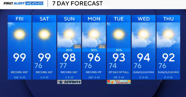
Temperatures in North Texas will remain near record levels through the weekend thanks to a strong ridge of high pressure.
Highs will climb into the upper 90s to around 100 on Friday afternoon, but lower dew points should keep the heat index fairly close to the actual air temperature. Winds will remain relatively light. An air quality alert is in effect.
On Friday night, temperatures will fall into the 70s across most of North Texas. Some locations outside of the Metroplex could reach the low to mid-70s by Saturday morning.
The daytime high on Saturday will be close to 100 again, and fire concerns will continue. Relative humidity could fall to around 25 percent in the afternoon, with winds from the south increasing to around 20 mph. With vegetation and soils extremely dry, any grass fire that develops could spread quickly.
The ridge finally begins to weaken on Sunday, allowing a front to gradually move south through the Great Plains and toward North Texas. A 20% to 30% chance for showers and thunderstorms develops as early as Sunday evening and continues Sunday night. The better opportunity favors areas north and west of DFW. There is a possibility of hail and strong wind gusts with some of the stronger storms.
The front should continue working south into North Texas on Monday, with isolated to scattered showers and thunderstorms possible. A few stronger storms could again produce hail or downburst winds. Unfortunately, this does not look like widespread soaking rainfall. Some locations could receive measurable rain while others receive very little or nothing.
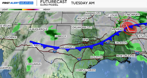
Another push from a stronger upper-level disturbance should help drive the front farther south and through most of North Texas Tuesday. Additional isolated to scattered showers and thunderstorms will be possible as the boundary moves through. While significantly cooler air is not expected behind the front, temperatures should finally move closer to seasonal averages.
By the middle of next week, high temperatures will hover in the upper 80s to low 90s.