Strong storms possible on Saturday afternoon with wind and hail in Pittsburgh | First Alert Weather

Today is a KDKA First Alert Weather Day with a line of strong to severe storms moving across the region after 1 p.m. as a cold front moves in.
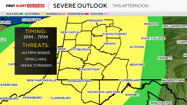
We are under a slight risk for severe weather, which is a 2 out of 5 on the scale, meaning a higher confidence for scattered strong to severe storms to develop. Damaging winds over 60mph will be the biggest threat. Small hail is possible, and an isolated weak/brief tornado can't be ruled out.
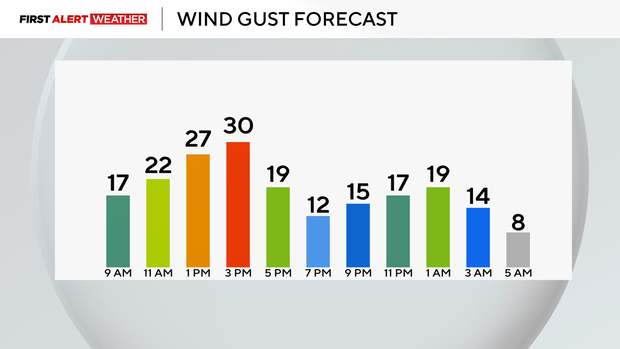
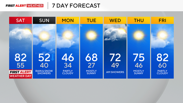
Once the line moves through, we will calm down and cool down through the evening and night. It'll be a chilly start tomorrow with falling temperatures during the day. We start off in the low to mid-50s at midnight, and morning lows will be in the 40s, which is actually seasonable.
A light mix is possible for some overnight and then again late Sunday into Monday morning, but little to no accumulation is expected.
We are still trending well above normal through mid-month, and we are already 11 degrees above normal. Today's highs will be in the low to mid 80s, with the record high being 90 in 1896. Our coldest mornings will be Monday and Tuesday, with lows for many at or below freezing.
Highs on Monday will only be in the upper 40s, but it's short-lived before the upper 60s and sunny skies return on Tuesday.
Heading into NFL Draft events this week, on Wednesday, there are a few showers possible early, but much of the week looks dry. We are back in the low 70s on Wednesday, mid 70s with sunny skies on Thursday and Friday, low 80s with more sunshine!
Saturday looks to be our next chance for rain with highs in the upper 70s.