Storm chances will move through the Pittsburgh area today

Storm chances will move through the Pittsburgh area today before temperatures cool off across the region this weekend.
Any alert days ahead? There is a chance for a First Alert Weather Day on Sunday morning with potentially the first freeze warnings of the season being issued for some communities.
While I can't rule out severe weather for today (parts of the area are under a marginal, level 1 out of 5, risk of severe storms), our severe storm chances will be VERY low. The window for severe storms appears fairly narrow, potentially opening up as soon as 11 a.m. and extending through 2 p.m. If in Pittsburgh, your severe storm chance will be done by 1 p.m.
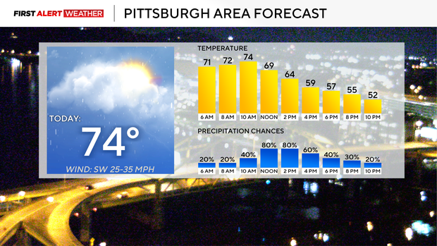
Today can really be separated into three parts. The morning hours ahead of the cold front and storms will be windy and VERY warm. Temperatures are already in the 70s as of 3 a.m., and I have highs hitting 74 degrees for a high. Before 11 a.m., it will be sunny and windy, with winds gusting to maybe as strong as 40 mph coming in from the southwest. This morning will be an ideal time to get outside and to walk the pups.
Once storms roll through, things will change with temperatures falling for the afternoon, light rain and drizzle around, and cloudy ominous skies. It'll remain breezy but not as windy as the morning hours. Winds will be coming in from the north-northwest at around 10-15 mph. Temperatures during this time won't be that bad with temperatures tumbling through the 60s and in the 50s by 5 p.m.
The final part of the day happens when the sun goes down as a trough settles in from the north with the really cold air behind it. I have temperatures already in the upper 40s by midnight in Pittsburgh. Saturday's high of 49° happens at midnight, with temperatures in the mid to upper 40s for the remainder of the morning and afternoon. Rain should come to an end during this final stage, with winds coming in from the north at around 10 mph. Skies will be mostly cloudy to partly cloudy Saturday morning, with clear skies expected for the afternoon.
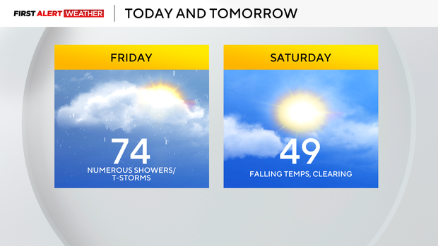
That'll set up near-freezing temperatures region-wide on Sunday morning as winds calm down. There is a lot of dry time next week with our next rain chance more than 10 days after this rain comes to an end.
This year's winter weather forecast
Just quickly I did promise to take a look at yesterday's winter weather forecast from the Climate Prediction Center, so here are my thoughts.
This winter is going to be a VERY warm winter. That doesn't mean we won't see our share of snow showers here or there. I fully expect we are going to get hit with a Colorado-type severe storm turned winter storm event this season
We will see several warm weather records set, with most of the records coming due to our lows being the warmest on record
Find out Ray's prediction for the season on November 23rd. Our yearly Winter Weather Special will air on Christmas and New Year's Day.


