North Texas gets one last summer push this week


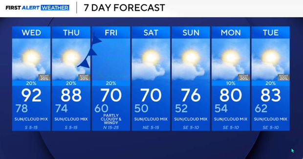
Our main weather stories are the summerlike heat and humidity through Wednesday, increasing rain chances across western and northwestern North Texas Wednesday night into Thursday, and a strong cold front expected late Thursday night into Friday morning.
The front will bring a significant change in our air mass, with gusty north winds, much lower humidity and temperatures dropping well below the levels we're experiencing early this week. By the weekend, afternoon highs will be in the upper 60s and 70s, with morning lows in the upper 40s and 50s.
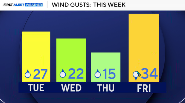
Tuesday is another very warm, humid and breezy afternoon across North Texas. Low clouds that developed overnight gradually lifted and scattered, allowing more sunshine and temperatures to climb into the lower 90s. We're forecasting a high around 92° in DFW, with heat index values approaching 100° as dew points remain in the upper 60s and lower 70s. South winds will increase to around 15–20 mph, with occasional higher gusts. A few isolated thunderstorms may develop during peak afternoon heating, south and east of the metroplex.
Warm and muggy conditions will continue overnight. Southerly winds will persist, transporting additional Gulf moisture northward. Another round of low clouds is expected to develop late tonight and spread into the metroplex toward Wednesday morning. Overnight temperatures will generally remain in the lower to middle 70s.
Hot and humid Wednesday as rain chances increase
Another hot and humid day, with temperatures again reaching the upper 80s and lower 90s. Heat index values could approach 100° for a second consecutive afternoon.
The upper-level trough over the western United States will gradually advance eastward, weakening the influence of the ridge that has kept us hot and relatively dry. Isolated to scattered afternoon thunderstorms will be possible, especially near and east of I-35, where abundant moisture and daytime heating will support instability. Rain coverage will remain limited for much of North Texas, and widespread rainfall is not anticipated. A stronger thunderstorm cannot be ruled out across western North Texas, although the overall severe weather threat remains low.
Rain chances begin to increase more noticeably across northwestern North Texas on Wednesday night. As the western upper-level system approaches, deeper moisture and stronger atmospheric lift will support additional showers and thunderstorms.
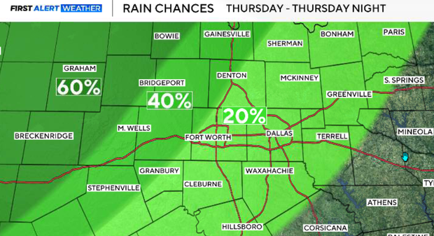
The best opportunities will be across our far northwestern counties, including areas closer to Wichita Falls and Graham. Rain chances will remain considerably lower toward the metroplex (20%).
Thursday stays warm ahead of cold front
Thursday will be an important transition day, but most of North Texas will remain warm and humid ahead of the approaching cold front. Highs should generally reach the 80s, with some locations approaching 90°.
Scattered showers and thunderstorms will continue across western and northwestern North Texas, where rain probabilities could reach 40–60% in favored locations. However, this will not be a typical situation where a solid line of thunderstorms advances southeast across the entire region.
The strongest upper-level forcing will remain northwest of DFW, creating a sharp gradient in rain chances. Some northwestern counties may experience periods of showers and thunderstorms while much of the metroplex and southeastern North Texas remain dry.
A strong disturbance diving southeast out of Canada will interact with the western upper-level trough, helping drive a strong cold front southward through the Plains.
The front is expected to sweep through North Texas late Thursday night into Friday morning. Although the front will be strong, the associated rainfall may be relatively limited as the strongest upper-level forcing lifts northeast of the region. The most noticeable impact will be a significant wind shift and the arrival of a much cooler, drier air mass.
Say hello to fall
Friday will have a very different feel across North Texas. Gusty north winds will develop behind the front, bringing a substantial decrease in humidity and cooler temperatures.
The exact temperature forecast will depend on frontal timing, but conditions should become increasingly comfortable as the day progresses. Any lingering rain chances will diminish as the front moves south and drier air spreads across the region.
This is the weather many of us have been waiting for. High pressure building into the region will bring mostly clear skies, much lower humidity, and genuinely cool mornings.
Saturday and Sunday, overnight and early morning temperatures will fall into the upper 40s and 50s, with afternoon highs generally in the upper 60s and 70s. Saturday is shaping up to be an especially pleasant day for outdoor activities. After several days of heat index values near 100°, the weekend will feel dramatically different.
Cool and dry weather should persist through much of the weekend before high pressure shifts east and southerly winds gradually return. Temperatures will begin moderating late Sunday into early next week. A lingering upper-level disturbance over the Southwest could eventually bring low chances of rain back to the region, but confidence in timing and coverage remains low.