Flash flood risk and storm chances remain in Pittsburgh on Thursday

Western Pennsylvania and northern West Virginia are under threat for more scattered strong to severe storms and flash flooding on Thursday.
Similar to Wednesday and previous days, the flash flood threat will be localized and highly dependent on where and when storms develop and track.
Fash flooding remains a threat
As of Thursday afternoon, activity was already forming in central and eastern Ohio and will continue to grow upscale in coverage and intensity as the afternoon progresses. The general window for storms for the entire area will be between 12 to 8 p.m., with the Pittsburgh metro seeing activity most likely between 2 to 6 p.m.
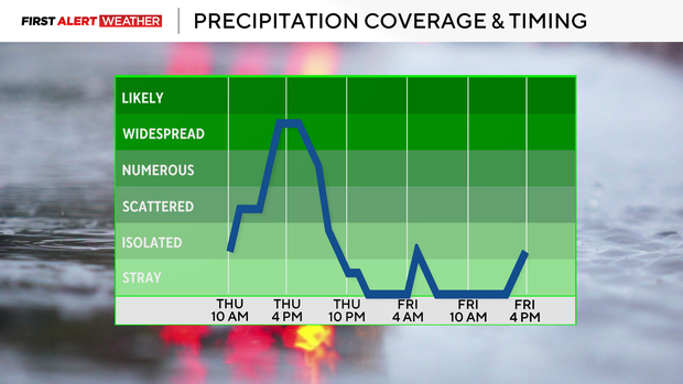
Gusty outflow winds up to 60 mph may occur along with some small hail. Gusty winds outside of storms are expected with the low pressure and cold front moving through the vicinity. Flash flooding still appears to be the overarching threat. Moisture levels are not as high as earlier this week, but any additional rain is enough to cause flooding, especially if half an inch to an inch falls in a given location in an hour or less.
Friday brings a quick reprieve from humidity
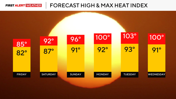
Once the storms exit, the area will get a brief reprieve from the excessively humid conditions on Friday. Most of the day will be sunny to partly cloudy with highs reaching the lower 80s. Friday will also be the coolest day before the area's first bout of excessive heat of the summer builds in as a strong ridge of high pressure aloft in the atmosphere starts to nose in for the upcoming weekend.
There will be one more opportunity for some isolated to scattered storms Friday evening into Saturday morning as a fast moving short wave moves across the region. The best chances appear to be north of Pittsburgh toward the I-80 corridor, and we cannot rule out an isolated strong to severe storm.
Pittsburgh to hit 90 degrees next week
Heat humidity levels will start to increase Saturday afternoon but will become most noticeable on Sunday. Sunday will likely feature the area's first 90-degree day of the year, and if we don't hit 90 on Sunday, there will be plenty of opportunity to do so next week.
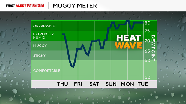
Most models are in agreement that the core of the heat dome will peak in intensity and park directly over the Ohio Valley and Mid-Atlantic states Monday and Tuesday next week. The saving grace for the Pittsburgh metro is that soil is very moist and the evaporation of this moisture should keep air temperatures in check, mostly reaching the low 90s.
Despite this, it will be very humid, and this will lead to heat indices around 100 degrees or maybe even hotter from Monday through Wednesday during the afternoon. The National Weather Service will likely issue heat advisories to account for this threat as conditions will be dangerous for those who don't have access to A/C, work outside or live with medical ailments.