Snow showers, gusty winds continue into Monday as temperatures plunge | First Alert Weather Day
What a change a day makes! Rain changed to snow right on cue midday Sunday, and winds picked up, gusting to more than 40 mph across the Pittsburgh region.
First Alert: Tonight through Monday morning; monitoring Thursday.
Aware: Snow showers and high winds persist overnight, temps plunge.
Climate: Average High: 40 | Average Low: 23
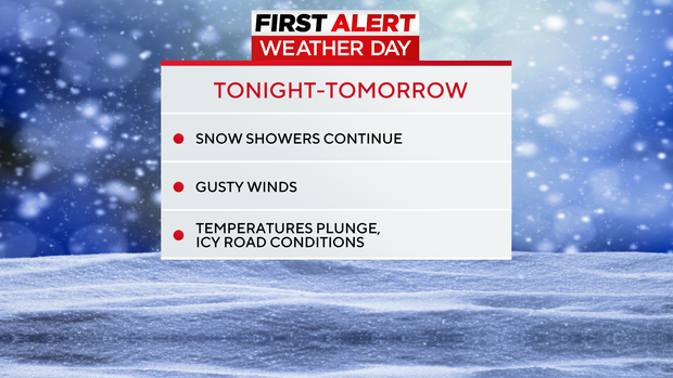
Steady snow has tapered off, but scattered to numerous snow showers continue tonight into the first half of Monday. The high winds wind continue and that has prompted a blizzard warning for Tucker, eastern Preston, and the ridges of Fayette and Westmoreland counties through Monday, where visibility could be very low with snow and blowing snow.
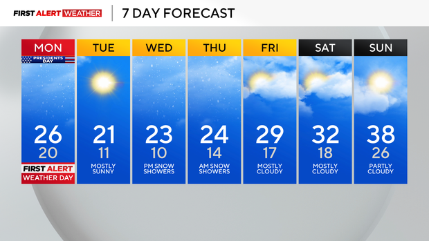
Elsewhere, snow showers will continue off and on through Monday midday before finally ending Monday afternoon. The Ridges and Laurel Highlands could end up with several more inches of snow through Monday afternoon (3-6") with generally around 1-2" at most accumulating in all other lower elevations across southwestern Pennsylvania.
Much colder temperatures arrive tonight, with icy conditions potentially developing on roads and lows near 20 degrees. Temperatures will hover very much below normal for mid-February all this week, with highs only in the mid-20s and lows reaching the lower teens.
Tuesday will be dry before another system approaches late Wednesday into Thursday. Right now, models bring it south of our area, with a few inches of snow possible, but mainly focused on the Laurel Highlands.
We will keep an eye on the track and update you through the early week.
WEATHER LINKS:
Current Conditions | School Closings & Delays | Submit Your Weather Photos
Stay up to date with the KDKA Mobile App – which you can download here!