It's going to be a dry day for the Pittsburgh area before rain chances move back into the forecast

It's going to be a dry day in the Pittsburgh area before rain chances move back into the forecast for the rest of the week.
Any Alert Days Ahead? Not right now.
Aware: When it comes to the 1st three days of August, Sunday's rain pushed us to the fifth-wettest start on record for the month.
It was a wet start to the month with Sunday's and Monday's rain, and after a little bit of a break today, more rain is on the way. Right now, model data is struggling to come up with some agreement on the amount of rain and timing of rain. The setup is there for isolated to scattered showers and storms for the rest of the week with the jet stream around and plenty of moisture available for storm development.
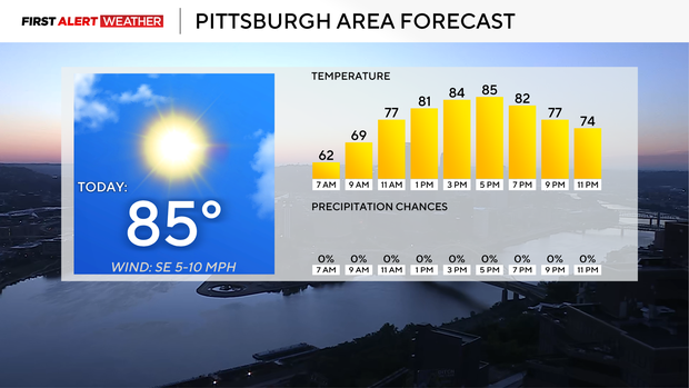
Today will be dry and sunny for the afternoon. The only concern I have is with patchy fog around in the morning. Any fog should be easily out of here by 9 a.m., with most out of here by 8 a.m. Morning temperatures bottomed out near 60 degrees. Temperatures should be near 80° at noon, and I have Pittsburgh hitting 85° for today's high. This afternoon will be pleasant as humidity levels remain low.
Most of Wednesday is also looking dry, with isolated storms possible during the afternoon, potentially turning scattered later in the day. Highs on Wednesday will hit the upper 80s with humidity levels ticking up to the moderate to high range.
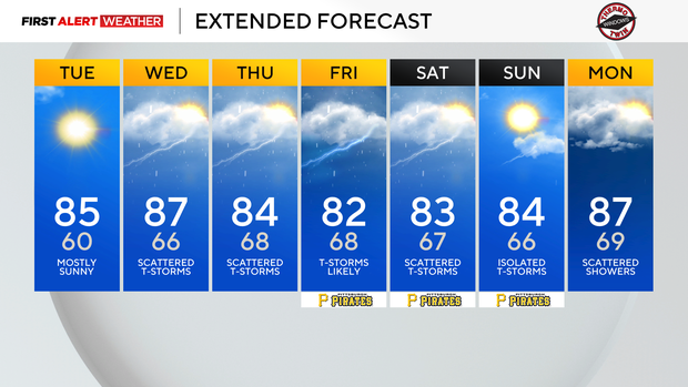
The rest of the week is looking rainy, with rain chances highest on Friday with a storm chance in place. I bring rain chances down from widespread on Friday to scattered on Saturday and Sunday, but it looks like light rain and drizzle will be around both days.


