Pittsburgh Weather: A soggy Saturday kicks off the weekend
PITTSBURGH (KDKA) - The rain still isn't done!
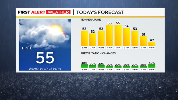
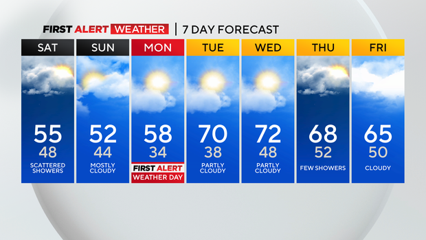
Today is not looking like a total washout like yesterday where we picked up around a half inch of rain. Scattered showers will still stick around today then taper off into tomorrow.
WEATHER LINKS:
Current Conditions | School Closings & Delays | Submit Your Weather Photos
Most of the showers will be in the morning hours. Since cooler air is filtering in, temperatures stay cool and below average side. Most of today will be in the mid-50s for highs, while tomorrow will be stuck in the 40s for most of the day. Highs on Sunday may touch the 50s for a few select towns.
If you have any outdoor plans, Sunday is still looking like the better day since it won't be as rainy just colder. In fact, if you were looking to get some foliage pictures in, we're experiencing our peak color over the next week and cloudy skies make for the best photos!
Next week, skies turn more partly to mostly sunny with no rain chances. There is going to be frost developing during the overnights Sunday night into Monday morning and also Monday night into Tuesday morning. Temperatures will fall into the low and mid-30s, so this will likely cause widespread frost across the region.
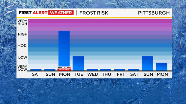
Any sensitive vegetation should either be covered or brought inside those nights! This is why we have declared a First Alert for Monday morning, just for the likelihood of frost that will impact the growing season.
This is running about a couple of weeks behind for the season. Highs eventually return back into the 60s and possibly low 70s by mid-week.
More rain arrives by Thursday with another cold front which will usher in more cool air for next weekend.
Stay up to date with the KDKA Mobile App – which you can download here!