How much snow will Pittsburgh get this weekend? It's too early to tell, meteorologists say.

Pittsburgh is bracing for a big winter storm system this weekend. But as for how much accumulation the area will get, it's still too early to tell.
Forecasters start to get a more precise idea of the impacts and timing of a system three to four days out. When the system is one to two days away, that's when there's a higher confidence for timing and accumulations.
"Where is it right now? Like where is the worst of it right now?" KDKA-TV's Barry Pintar asked First Alert Meteorologist Ron Smiley on Wednesday.
"Okay, so it hasn't even formed yet," Smiley said.
Still, meteorologists expect it will be a major system impacting a large swath of the country.
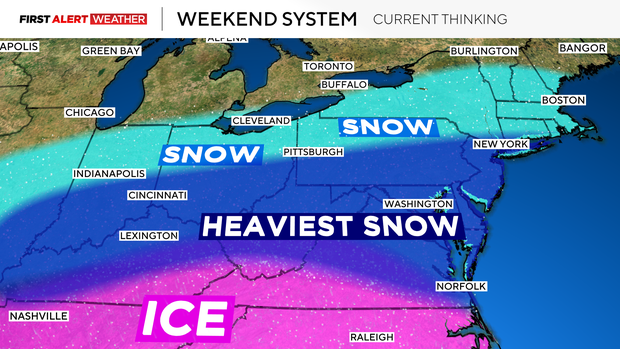
How do meteorologists make the forecast?
Amazing meteorological science is behind all of these predictions. Multiple weather watching tools are used to predict not only how, but where.
"At this point, even hourly, we have data that's coming in every hour, but our main model runs come in four times every day," KDKA First Alert Meteorologist Ron Smiley explained. "And we have atmospheric data from the National Weather Service. They send up weather balloons twice a day. So all of this comes together to give us a pretty good detailed look, or pretty good look, at what we can expect when it comes to forecasting."
While it's still too early to tell how much accumulation western Pennsylvania will get, one thing is clear: plan for snow.