Another dry stretch of weather in the Pittsburgh area continues into the weekend

Good morning, the new drought maps being issued by NOAA's U.S. Drought Monitor are expected this morning.
WEATHER LINKS:
Current Conditions | School Closings & Delays | Submit Your Weather Photos
I expect that we will see slight improvements across the board for the week, with any improvements being short-lived for now. Today will be the sixth day without rain, and we will likely push the streak up to around 10 before we see any rain in our area.
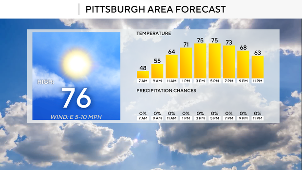
While we wait for rain, the weather is going to be fantastic once again today with highs hitting the mid-70s.
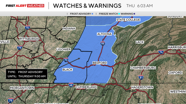
However, a Frost Advisory is in place for the Laurel Highlands until 9 a.m.
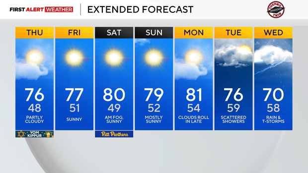
This fantastic stretch will roll on through the weekend with highs in the mid to upper 70s on Friday and highs near 80 degrees over the weekend. The only weather issue over the weekend is the chance for some patchy fog on Saturday morning as warmer air rolls in and is cooled by the dry and cool air already in place.
This type of setup often leads to some of our thicker fog days, so we will see it there.
Looking at next week's rain chances, I have an isolated rain chance on Monday, but it really looks like Monday will be dry. Long-range data isn't in agreement on the timing of the rain, with the GFS model showing rain arriving on Tuesday morning and continuing off and on through Wednesday.
The EURO model holds rain off until Wednesday, but rain totals are coming in higher when compared to the GFS model. We could potentially need to add a First Alert Day to next Wednesday due to a flooding risk.
The chance of that appears low at this point.
Stay up to date with the KDKA Mobile App – which you can download here!