It's going to be a day of warm temperatures in the Pittsburgh area before high winds ramp up tonight
It's going to be a day of warm temperatures in the Pittsburgh area before high winds ramp up tonight.
FIRST ALERT: Strong winds Sunday night through Monday night.
AWARE: Colder weather for the New Year
Rain arrives this morning and temperatures soar to the upper 50s, seeing a high near 60 around midnight. There will be dry time if you want to go outside and enjoy.
Secure those Christmas decorations because winds ramp up tonight and all-day Monday.
Monday morning will be mild with temperatures in the 50s waking up with a quick round of heavy rain. Areas could pick up about .25-.5" of rainfall.
Rain switches to snow showers Monday night with about 1-2" possible.
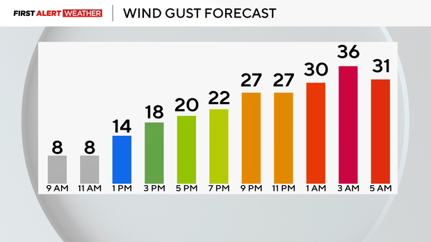
Winds ramp up after midnight, which is why we have a Wind Advisory going until 1:00am on Tuesday.
A High Wind Watch that could become a warning is in place for the Laurel Highlands and northwestern parts of Maryland with gusts up to 50-60mph. Power lines could go down along with trees, so stay weather aware.
Here in Pittsburgh, winds will be around 30-40mph all day. With those winds and falling temperatures, we will feel in the teens for much of the day tomorrow and then single digit wind chills Tuesday.
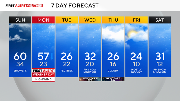
We hold onto that cold air through the start of the New Year with scattered snow showers. New Years Eve will be cold at night with snow showers possible and low temperatures in the teens and 20s. We copy and paste those below normal temperatures all the way through next week so bundle up!
WEATHER LINKS:
Current Conditions | School Closings & Delays | Submit Your Weather Photos


