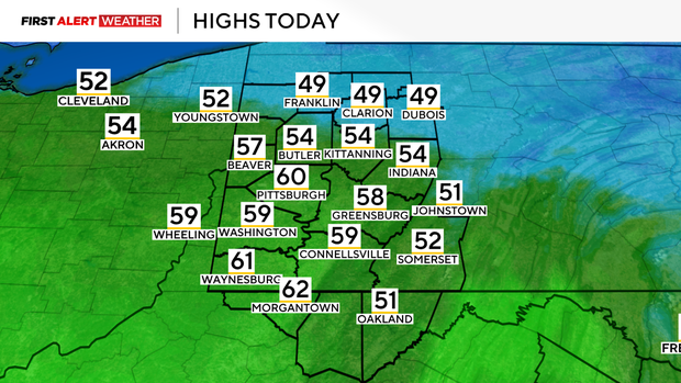
Pittsburgh area to see warmest day of the week on Monday
PITTSBURGH (KDKA) - While the Pittsburgh area warms up today, don't expect the warmth to mean little winter weather will be in place for the week.
It actually looks like there will be a big fight between cold and warm air right on top of the Pittsburgh area over at least the next two weeks. There will be several precipitation chances including light rain Monday night, a wintry mix of precipitation is expected both on Wednesday and Thursday, and again on Saturday.
The issue at this time of the year is that temperatures can be warm enough for just rain in Pittsburgh, but cold enough for freezing rain or snow just 20 to 30 miles away. This happened Sunday when nasty freezing rain fell in Indiana County. This caused a number of wrecks with iced-over roads.
I-80 was temporarily closed at one point on Sunday. While conditions may not end up getting back to that point later on this week and next, it's certainly possible.
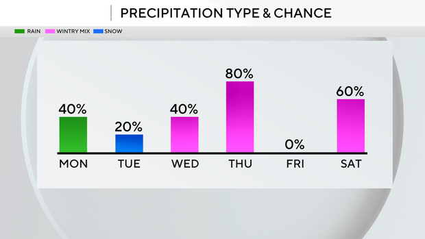
The other issue is that it doesn't take a lot in the way of drizzle or light rain to cause slick conditions. This means on days like Wednesday, where rain totals will be lower, the risk of icy conditions could still be high. I have a mix of rain, snow and some type of a mix being possible on Wednesday, Thursday and Saturday.
Expect highs near 60 degrees on Monday for Pittsburgh. Highs will only be near 50 degrees though for places along and north of I-80. Noon temperatures should be near 50 degrees. Besides Monday, Thursday highs should hit the mid-50s.