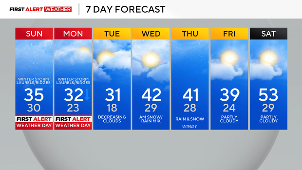
Winter storm and heavy snow for the Laurel Highlands and Ridges Sunday into Monday
Most of the Pittsburgh area was in the dry slot following a departing strong low-pressure and cold front that produced record rainfall at Pittsburgh International Airport on Friday.
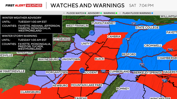
First Alert: Sunday-Monday (only the Laurel Highlands and the Ridges)
Now, we are watching the next storm system to approach our region from the west. This storm system is in its developmental phases now, with a couple of pieces of spin/lift over the Midwest and Deep South. These separate components will not phase, however, until the whole system gets to the East Coast, so instead of hitting western Pennsylvania and the Upper Ohio Valley at peak maturity, it will be in a strengthening phase, which will help a large portion of our area not receive as much snow.
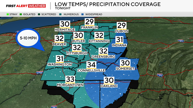
Scattered to numerous snow showers are expected to arrive after 10 p.m. through Sunday morning. Temperatures for most of the night will be near or slightly above freezing, which should limit the impact of ice forming. A more persistent band or several bands of snow will take shape after 12-1 p.m. over our eastern and southeast counties into the Laurel Highlands, Ridges, and central Pennsylvania.
This is due to upslope flow and enhanced lift aloft in the atmosphere as the storm system matures. This band will persist into the predawn hours of Monday, while areas west of the Laurels see periodic snow showers.
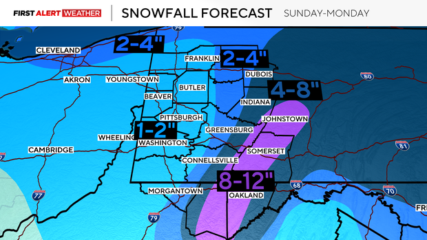
Total snowfall amounts from Sunday through Monday night will range from 1-2 inches in the Pittsburgh metro area/I-79 corridor. Amounts will steadily increase with terrain as 4-8 inches along and east of the Route 119 corridor, then 8-12 inches in the peaks of the Laurel Highlands.
Snow showers will end, and gusty winds will diminish on Monday night into Tuesday as high pressure moves into the region.
Tuesday will feature decreasing clouds by late afternoon and evening, but this clearing will be brief. Another disturbance moving in from the Great Lakes will force more snow mixed with rain to develop Tuesday night into Wednesday. Temperatures will warm above freezing on Wednesday morning thanks to a southwest wind, so impacts should be brief and short-lived. A third low-pressure system will approach from the southwest on Thursday with more rain and snow.
The farther north you are in our area on Thursday, the higher the chance of precipitation being snow, while a precipitation type of rain is favored farther south. Once this system passes, a brief warming trend looks to take hold in the first part of next weekend.