Intense storms bring tornado warnings, widespread damage and power outages to Pittsburgh area


A powerful line of severe weather smacked the Pittsburgh area Thursday evening, leaving more than 120,000 customers without power.
The National Weather Service issued several tornado warnings as destructive winds and torrential rain hit the region in the evening. The rainfall prompted flash flood warnings after storms had already hit communities on Thursday morning.
Photos and videos showed cars submerged in water, debris scattered across roads, downed trees and power lines, among other hazards. Lesser storms hit Thursday night as the area began to clean up.
Duquesne Light power outages
As of 9:20 p.m. on Friday, more than 7,000 customers in the Pittsburgh area are without power.
"DLC expects all customers to be restored by 4 p.m. Sunday, Sept. 6, with many restored sooner," the power company said in a news release.
First Energy power outages
As of 9:15 p.m. on Friday, more than 27,000 customers in the Pittsburgh area are without power.
Flash flood Pittsburgh
Pittsburgh Mayor Corey O'Connor said on social media Thursday night that the storms created "dangerous conditions" across the city. He urged people to stay safe.
"Significant rainfall from the severe thunderstorm has created flooding conditions and brought down trees and power lines in several areas of the city," Pittsburgh Public Safety said on social media.
Drivers should remain cautious, and officials remind people never to drive through flooded roadways.
"Please heed all road barriers as they are there for your safety," Pittsburgh Public Safety said. "Turn around, don't drown!"
Assessing the damage
The wind caused a tree to fall outside the Eat'n Park in Unity Township, Westmoreland County, crushing a vehicle in the parking lot.
In Beaver Borough, Beaver County, a potential microburst rolled through, leaving a path of destruction as numerous trees were knocked to the ground. Resident Carl Grunert described the scene as a "minefield," while resident Sam Wagner said it was "intense."
"It was pretty crazy," Wagner said. "I've never seen the wind blow that hard."
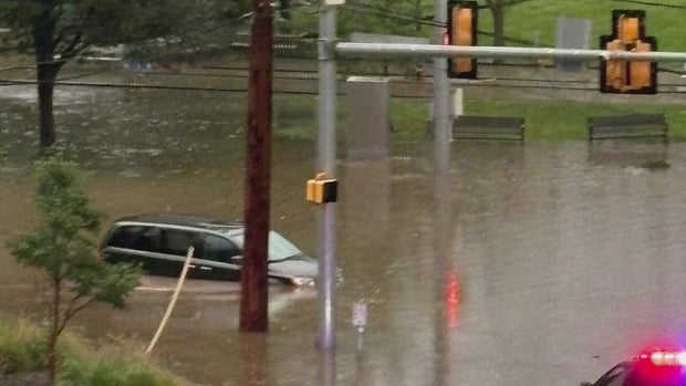
In Allegheny County, a vehicle was submerged in high water near Cedar Boulevard and Greenhurst Drive in Mt. Lebanon, and the Oakmont Volunteer Fire Department told residents to avoid unnecessary travel due to the "dangerous conditions."
The National Weather Service said the severe threat ended for the entire region at 11:40 p.m. on Thursday.
"Outside of a stray shower/brief thunderstorm, no other weather is anticipated," NWS said.
Multiple schools in Pittsburgh switch to remote learning
After Thursday night's storms, and with many areas still without power on Friday, several schools across the region have either switched to remote learning or are closed for the day.
You can find a full list of closings here.


