Pittsburgh's high temperature will reach into the 60s on Friday, most of the day will be dry
I expect that Pittsburgh will hit 60 degrees for today's high. While it doesn't happen a lot, it isn't too rare a feat, with most years seeing at least one 60-degree day in January. The last time we hit 60 degrees in January was in 2024. We hit 60 degrees twice in 2023. We failed to hit 60 degrees in January in both 2022 & 2021, but hit it twice in 2020.
WEATHER LINKS:
Current Conditions | School Closings & Delays | Submit Your Weather Photos
Generally, it looks like we average just over one a year, with the most being in 1950 when we hit the 60° mark nine times. The most, over the last decade, was the four times we accomplished the mark in 2017.
Impressive.
Today's record high mark is 69°, and we won't be close to that. It will still feel fantastic.
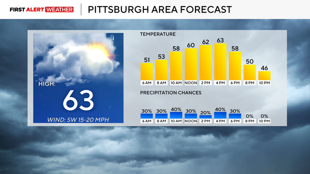
While us hitting the 60s in January is also a nice lead weather story, we also have to talk about today's rain chance. Most of your day today is going to be dry, but rain chances will be around with the best chance for rain happening after 8 a.m. through noon. Expect scattered rain during this time.
We will also have a chance for rain briefly around 5 p.m. this afternoon. A skinny line of rain will bring windy conditions with winds gusting potentially up to 40mph. The second round of rain will not last long, less than 30 minutes, with winds calming down within the hour.
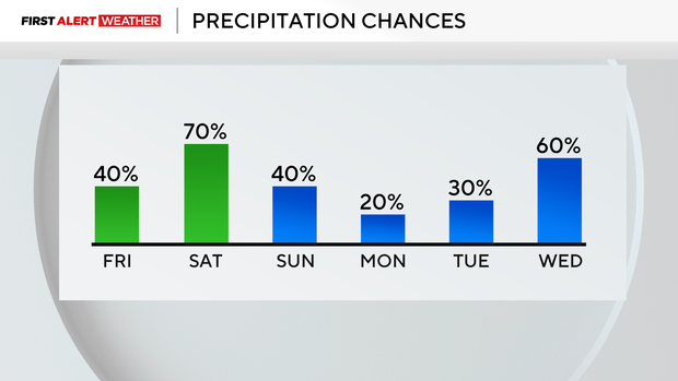
Saturday's rain chance will be higher than today's, with a couple of chances for widespread rain. Even with that, there will be some large gaps in the rain for you to get out and enjoy.
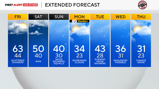
I have dropped Saturday highs to just 50 degrees, so it won't be as pleasant during the still abundant dry time we will see. At this point, it looks like the best chance for rain will come from 4 p.m. - 9 p.m., with another chance for rain happening in the morning. 2 day totals for rain should be around a quarter of an inch in Pittsburgh, with rain totals of maybe a half inch for places in the Laurel Highlands & Ridges of Fayette and Westmoreland counties.
As we head into Sunday, temperatures will be rapidly dropping with snow showers expected throughout the day.
The impact on area roads should only be minor with temperatures most of the day remaining above 32°. Higher elevations, especially westward-facing slopes of the Ridges and Laurel Highlands, will have a higher chance for travel to be impacted as usual.
Once Sunday arrives, winter returns with temperatures remaining more seasonal for the rest of the week.
At this point, it looks like we will have a couple of chances for snow over the next ten days, but the chances are so slow with each event that I am not going to focus on any of them until the chances become higher.
Stay up to date with the KDKA Mobile App – which you can download here!