Freezing rain expected to impact parts of western Pa. tonight into Thursday morning | First Alert Weather Day

PITTSBURGH (KDKA) - Clouds continue to stream across our region today ahead of a developing storm system to our southwest. This system will bring widespread precipitation to our region, starting well after sunset and lasting into the midday hours of Thursday.
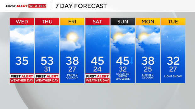
First Alert: Wednesday evening through 10 a.m. Thursday (freezing rain); Saturday (freezing rain, mixed wintry precipitation).
Aware: It's been 781 days since the last ice storm warning has been issued.
The setup involves a retreating shallow cold air mass, with a deep layer of warm air moving in from the southwest atop that cold air. This leads to the development of freezing rain and some sleet.
Ahead of tonight's precipitation, skies will remain cloudy, and temperatures are expected to max out in the 30s to near 40 degrees. After sunset, temperatures will drop to or even below freezing for areas from Pittsburgh and points north toward I-80 and the Laurel Highlands.
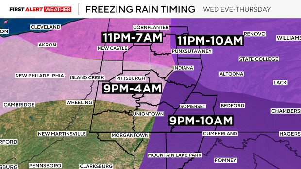
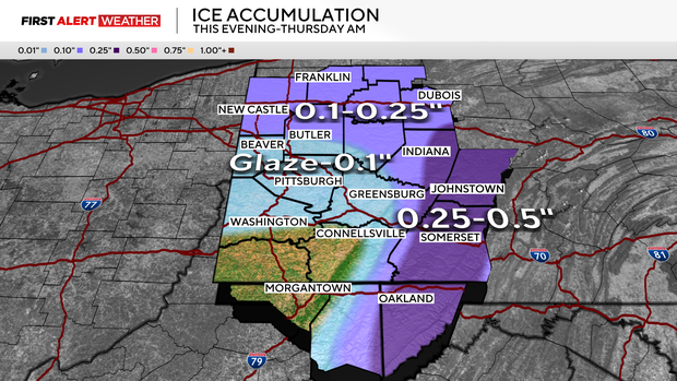
Precipitation will begin around 8-9 p.m. across our southwest zones and then gradually move northeast as the evening and overnight hours progress. For areas south and west of Route 422 and west of the Laurel Highlands, the duration of freezing rain should be brief and end by 3-4 a.m. The freezing line will eventually move north of Route 422 toward the I-80 corridor between 4-8 a.m. Thursday, which will lead to slightly higher ice accumulations in this zone due to the longer duration of freezing rain.
The heaviest icing is expected to occur in the Laurel Highlands and Ridges, especially for valleys and eastern slopes where the shallow cold air will be slower to retreat Thursday morning. This is where 0.25"-0.5" of ice will be possible, leading to minor damage in spots and very difficult travel conditions. Even the areas that receive lighter icing will still have slick roads, but the timing shouldn't last as long.
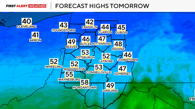
Precipitation will end midday Thursday, and temperatures will briefly spike into the 40s and low-mid 50s ahead of a cold front that will move in between 6 p.m. and midnight. This will result in falling temperatures and cold air moving in on Friday.
Temperatures will likely hold in the mid to upper 30s most of Friday with partly cloudy skies. This will be ahead of another wave of low pressure that will bring milder, moist air from the southwest atop a retreating shallow cold air mass. Sounds familiar, right? This means Saturday will have the potential for more freezing rain and sleet during the afternoon and evening hours, especially for areas north of Route 422 toward the Ridges and the Laurel Highlands where cold air will linger longer.
Temperatures briefly spike late Saturday night into Sunday morning before another surge of cold air moves in early next week.

This could be accompanied by another round of snow, possibly next Monday night into Tuesday, over parts of the area.
WEATHER LINKS:
Current Conditions | School Closings & Delays | Submit Your Weather Photos