Pittsburgh residents may need to start the air conditioners with temperatures in the 80s Thursday
Today's record high is 90°, set back in 1925. If we hit 85°, we'd be tied for the fourth warmest April 24th on record. If we somehow manage to hit 86°, we'd be tied for the second hottest.
WEATHER LINKS:
Current Conditions | School Closings & Delays | Submit Your Weather Photos
It's going to be the perfect mix of sunny skies, low humidity, and light winds that will make highs soar to the mid-80s for today. \
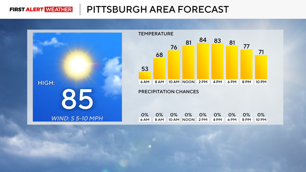
I feel I am being fairly aggressive with temperatures, bumping up my forecast high for today to the mid-80s, but with conditions as they are, I may not be aggressive enough.
Besides the heat, today is looking fantastic.
You won't need your jacket to start off the day with morning temperatures in the mid to low 50s. Temperatures will surge to near 70° by 7 a.m. We may already be in the 80s by 11 a.m. As hot as today is expected to be, it won't even be in the hottest of the month so far, as we hit 86° last Saturday.
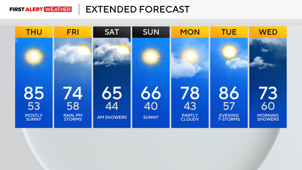
Next Tuesday, the 29th, temperatures may be even warmer than today as well. I have us seeing a high temperature of 86 next Tuesday, and that may go up. The record high for next Tuesday is 88°. The stretch of hot weather will be temporarily broken this weekend.
Rain showers will come in on Friday with scattered showers throughout the day expected, and isolated thunderstorms possible right around sundown. Rain totals on Friday should be more than three-quarters of an inch but less than an inch on average. The best chance for rain will come during the afternoon to evening, and could cancel practices and games occurring outside. Most of the rain should be out of here by just after sunrise on Saturday, leading to damp conditions on the area soccer fields. Any morning runs should feel fantastic on Saturday morning.
Morning lows on Saturday will be in the 50s, with temperatures remaining in the mid to low 50s for the afternoon too. Saturday's low temperature will occur just before midnight on Sunday.
Skies will clear late Saturday, allowing us to see temperatures plummet to the 30s in most areas on Sunday morning. Sunday highs should be back in the mid-60s. Looking ahead, there is a chance for severe storms next Tuesday.
Right now, it looks like the storm chance would arrive after 5 in the afternoon.
Stay up to date with the KDKA Mobile App – which you can download here!