El Niño is likely to form this summer. Here's what it could mean for western Pennsylvania.

You may have heard about the upcoming El Niño that is supposed to take shape this summer and potentially become very powerful by this fall into winter. Let's dive into what this means, how it forms, and how it may potentially impact the weather pattern in western Pennsylvania for this summer and beyond.
What is ENSO?
El Niño is just a phase or part of ENSO, the El Niño-Southern Oscillation. It is an interannual mode of climate variability with three phases: neutral, warm (El Niño), or cool (La Niña). By far, ENSO has the greatest influence on weather patterns across the globe.
ENSO is a natural part of Earth's climate system that exhibits variability over the span of a few years. To determine the current phase of ENSO and how that phase may or may not change, we look at sea surface temperature anomalies over the Equatorial Pacific Ocean and what is occurring underneath the surface by up to several hundred meters.
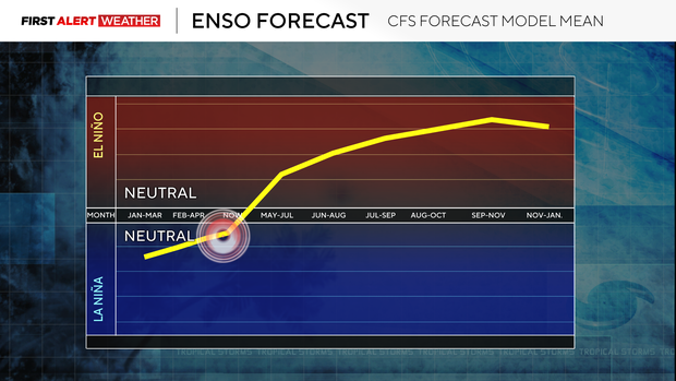
Right now, we are currently in the neutral phase of ENSO and are projected to head toward a strong warm phase or El Niño by mid-late summer that will last into the fall and upcoming winter.
What initiates and causes the shift?
Let's start with the Walker Circulation, which is the physical mechanism that initiates and influences where warmer and cooler than normal seawater resides near the Equatorial Pacific Ocean.
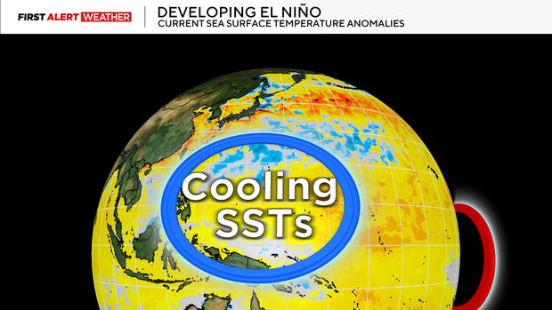
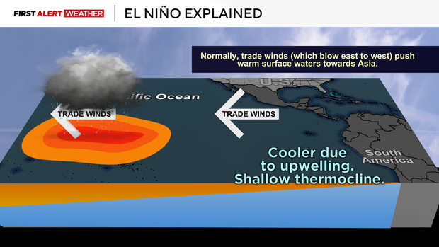
In the neutral phase of ENSO, the warmer sea surface temperatures are west of the International Date Line near Indonesia while cooler sea surface temperatures are positioned west of coastal South America. Above the warmer waters, we see enhanced rising motion leading to increased thunderstorms in the western Equatorial Pacific Ocean. While air rises and diverges in the upper atmosphere over the western Equatorial Pacific Ocean, it then converges and sinks over the eastern Equatorial Pacific Ocean. This sinking motion diverges at the ocean surface and helps enhance the trade winds which blow from east to west.
The east-to-west trade winds are responsible for upwelling and maintaining the cooler waters near the Equatorial East Pacific Ocean. When these trade winds are enhanced, we see a stronger upwelling of cooler water in the Equatorial East Pacific and a piling up of warmer waters and enhanced thunderstorms in the equatorial West Pacific. This is called La Niña.
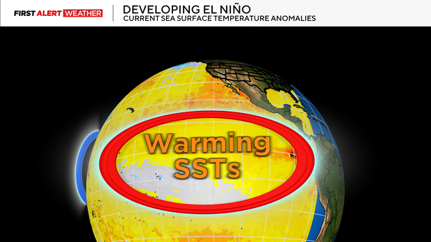
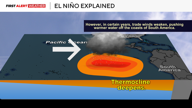
However, when those trade winds weaken, this slows the upwelling process and the warmer sea surface temperatures from the western Pacific Ocean migrate east through enhanced low-level westerly wind bursts. Once the waters in the relative Niño3.4 region— the area monitored in the Equatorial Pacific Ocean to assign the ENSO index — warm to a certain threshold above normal (greater than or equal to +0.5 degrees Celsius) for at least five consecutive overlapping three-month periods, then an El Niño can be declared.
What are the latest trends and projections with this El Niño?
According to NOAA's Climate Prediction Center, El Niño is likely to emerge between June to August 2026 and persist through the end of the year. El Niño is pretty much expected by the end of year, and it's likely that we'll be dealing with a strong or very strong El Niño. The stronger the El Niño or La Niña, the more influence it has on the global weather patterns.
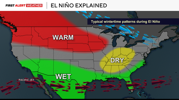
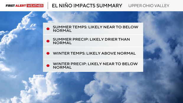
What El Niño means for western Pennsylvania
So how can this year's setup influence summer patterns, and what does it mean for western Pennsylvania if El Niño persists into the winter?
When answering this question, it is extremely important to note a few things: no two El Niño or La Niña events are exactly alike. There are other factors that influence global weather patterns outside of ENSO, and planetary warming induced by human-caused climate change may cause modern-day El Niño, La Niña, and neutral episodes to behave differently compared to a past climate. We can still look at previous years with similar conditions to get a proxy and make an inference of how the upcoming year may trend.
For this year, 2023 is the closest modern-day match under this climate regime to how this El Niño is likely to evolve this summer. For western Pennsylvania, that summer featured near to slightly below normal temperatures and near normal summer precipitation. The following winter featured well above normal temps and slightly above normal precipitation.
1976 is next on my analog years list. This featured a weak to moderate La Niña early in the year, but El Niño emerged more slowly (like 2026 projections) and became very strong by late year. Summer temperatures were below normal with below normal precipitation. That following winter was much drier than normal.
1982 is my third analog year. Unlike 2026, 2023 and 1982, there was no winter to early spring La Niña, but El Niño emerged more slowly (like 2026 projections) and became very strong by late year. During the summer, below normal temperatures were dominant with below normal precipitation. The following winter featured slightly above normal temperatures and below normal precipitation.
1991 and 1997 are also two years on my analog lists. The two commonalities among these years were below normal precipitation during the summer and a drier and warmer than normal following winter as El Niño peaked in intensity.