Cloudy skies, cool temperatures linger around Pittsburgh Saturday ahead of warmer temperatures, storms chances
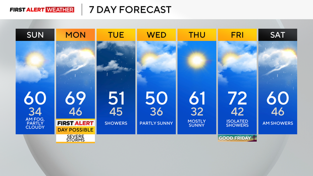
After a mainly cloudy Saturday, patchy fog will arrive early Sunday morning, followed by eventual clearing and a pleasant end to the weekend.
First Alert: Possible Monday (Afternoon/Evening Severe Storms)
Aware: Warmer Sunday with evening showers, up and down temps through the week.
Climate: Average High: 61 | Average Low: 40

Lows tonight dip into the lower to mid 30s with highs Sunday climbing to near 60, which is normal for early April. A few brief showers will swing through Sunday evening, and Monday will be dry and mild until late afternoon/early evening when a cold front arrives bringing a chance for a line of strong to severe storms.
The main threat would be gusty, damaging wind.
The Storm Prediction Center in Norman, Okla., has placed most of our area in a level 2 out of 5, or "Slight Risk," for severe storms.
Cooler temps settle in behind the front Tuesday and Wednesday with occasional showers and even a wet flake mixing in through the Laurel Highlands.
Warmer air finally returns just before Easter weekend, but showers could dampen Good Friday.
WEATHER LINKS:
Current Conditions | School Closings & Delays | Submit Your Weather Photos