Pittsburgh has a dry start to the week, but multiple rain chances move in later on
It's been a changeable day on Sunday, with sunshine alternating with clouds and breezy conditions continuing into this evening.
WEATHER LINKS:
Current Conditions | School Closings & Delays | Submit Your Weather Photos
First Alert: None
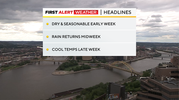
Aware: Dry start to the week/rain midweek/cooler than normal late week
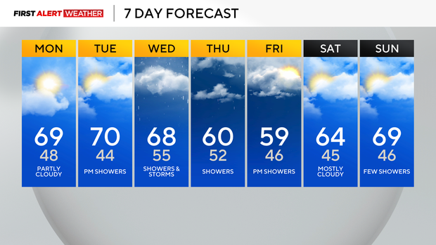
Almanac: Average High: 72 | Average Low: 51
Later tonight, the skies clear a bit and the winds die down. Lows will dip into the upper 40s to the lower 50s.
High pressure nudges closer to our region Monday, bringing a bit more sunshine and seasonable temperatures in the lower 70s.
Tuesday evening, and especially on Wednesday, rain chances will start to increase as a very slow-moving wave of low pressure migrates from the Plains to the Great Lakes States, leaving grey, dreary, damp, and cool conditions.
Much cooler air invades Thursday behind this system with more showers and highs struggling to reach 60 degrees. Temperatures begin to moderate as we near the Memorial Day weekend, with highs back near 70 Friday and seasonable temps all during the holiday weekend.
Stay up to date with the KDKA Mobile App – which you can download here!