After Ice Storm, Delaware Valley Tree Surgeons Get The Call... Stat!
This latest round of winter weather won't be profitable for the snowplow drivers, but it will be for the companies that take down damaged trees.
Watch CBS News
This latest round of winter weather won't be profitable for the snowplow drivers, but it will be for the companies that take down damaged trees.

"We are in a crisis here," says Mary Davis of Davis Feed Mill, in Rushland (Bucks County), Pa. Her company sells salt in bulk but has had to institute rationing.

Check here to see if your community event has been canceled due to the weather.

A Winter Storm Warning will continue into Wednesday for snow and ice with the biggest threat North and West of Philadelphia. In addition to hazardous travel Wednesday morning, significant icing of .25-.5" could take down tree limbs and power lines especially in our far NW suburbs and the Lehigh Valley.
This wild week of wintry weather continues. Round one yesterday and round two is just a few hours away. Our next storm will bring it all: Snow, Ice & Rain. This triple threat will bring many problems and this time location is everything.

Despite a brief break, the active weather pattern will get underway again Tuesday night. Our second large storm of the week moves in overnight into Wednesday morning as a mixed bag of snow, ice and rain (which could freeze on contact).

Tuesday will literally be the "calm before the storm". STORM #2, that is.
Check here to see if your community event has been canceled due to the weather.
Check here to see if your community event has been canceled due to the weather.

"It has a lot of wetness to it -- a whole lot of rain, so it's more wet than the other snow," noted one man who was clearing a sidewalk in center city Philadelphia.

And what happens if there is still more snow?

As moisture arrives overnight, temperatures will be warm enough for rain, then change over to snow as the colder air filters south and east.

The National Weather Service pegs snow amounts Monday at 4 to 6 inches, but anywhere from less than 3 inches south to perhaps an isolated 6+ inches could occur.

An active weather pattern returns for three storms setting up to impact the region this week.

With more people using Septa's Regional Rail lines, the transit agency is looking for ways to increase capacity.
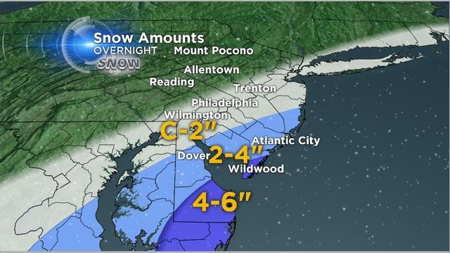
The heaviest snow will fall South and East of Philadelphia.
The Eyewitness Weather team is once again tracking a major Southern Winter Storm that will bring snow to parts of our area overnight.
The core of the arctic air mass has settled into the Delaware valley today. It wasn't record cold but low temperatures did get down into the single digits in the suburbs and 12 degrees in Philadelphia.

"We're trying to look for that predator that's preying on the vulnerable," says Septa police chief Tom Nestel.

The latest arctic blast will continue to create gusty winds and drive wind chills below zero Tuesday morning.

The extreme cold weather is once again causing ice jams in our area, as well as producing falling ice.

Saturday's clipper system that dropped around 2" of snow across the region has bumped Philadelphia into the #4 slot for snowiest January.

Another winter blast blanketed the region Saturday with a modest covering of snow, but it still caused some problems for area residents.

January 2014 has already made it into weather history as the 5th snowiest January in Philadelphia with 22.5" of snow at it could climb even higher Saturday with more accumulating snow!

As retail outlets, restaurants, and other places of business found themselves working with skeleton crews on Wednesday, SEPTA says it did, too.