Canadian wildfire smoke hits Philadelphia region Thursday, prompting air quality alert

Thursday morning in the Philadelphia region is already going to feel brutal before most people even finish their first cup of coffee. A code red air quality alert is in effect as Canadian wildfire smoke hits the area.
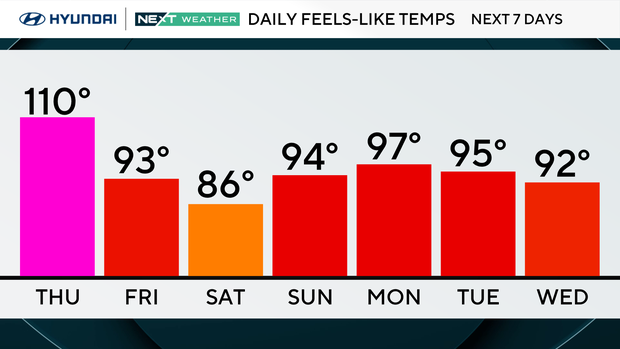
The heat index values are climbing to feel like the 100s by the afternoon. Actual temperatures reach into the mid-90s, but a dew point in the lower 70s is what makes this one really stick to you.
If you have outdoor work on the schedule, try to knock it out early and take frequent breaks in the shade. Because the combination of heat and humidity raises your heat exhaustion risk fast. Even a short walk with your pet could be dangerous on pavement that hot, so keep outdoor time brief and bring water for both of you.
A very high UV index on Thursday means sun protection is not optional, so layer on the SPF and wear a hat if you have to be outside. It's best not to be, however, as smoky skies may give way to poor air quality during the afternoon. Evening storms may pop up, bringing some relief but also locally heavy rain and lightning.
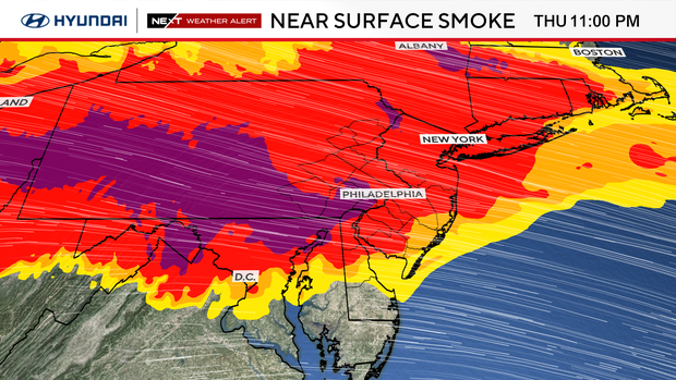
What to know about Canadian wildfire smoke in Philadelphia
As wildfire smoke continues to push into our region, Dr. Ruth McDermott-Levy, a professor at Villanova University and the co-director of the Mid-Atlantic Center for Children's Health and the Environment, said those with preexisting conditions should pay extra attention to the conditions outside.
"Wildfire smoke is among the most toxic air pollution we have," she said. "It burns whatever is in its path, so things that are not intended to burn are burned, and then also it travels very far so we're dealing with wildfire smoke from Canada. Along the way it picks up pollutants too."
McDermott-Levy said people might deal with a scratchy throat, itchy eyes and maybe a stuffy nose.
NEXT big weather changes
Looking at the extended pattern, the possibility of a significant storm system arrives this weekend and brings a welcome but potentially hazardous pattern change, and will knock highs back into the 80s.
Expect thunderstorms and the potential for heavy rain, meaning flash flooding is a real concern alongside any severe weather on Saturday as gusty winds pick up.
Behind the front, Sunday clears out nicely with skies becoming mostly sunny and a more comfortable low 80s high, with overnight lows dipping to the mid 60s, actually a few degrees below normal.
The following week brings a brief return to the mid-to-upper 80s before another round of scattered thunderstorms is possible Tuesday into Wednesday.
Here's your 7-day forecast:
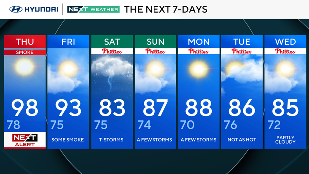
Thursday: NEXT Weather Alert for wildfire smoke. High 98, low 79.
Friday: Some smoke. High 93, low 75.
Saturday: Thunderstorms. High 83, low 75.
Sunday: A few storms. High 88, low 74.
Monday: A few storms. High 88, low 70.
Tuesday: Not as hot. High 86, low 76.
Wednesday: Partly cloudy. High 85, low 72.


