Warm in Philadelphia today, tracking heavy rain and severe storms on Wednesday
Meteorological winter has ended, and right on cue, Mother Nature will bring us our first taste of severe storms on Wednesday. More on that in just a bit. First, we'll take a quick look back at the winter.
A look back at meteorological winter in Philadelphia
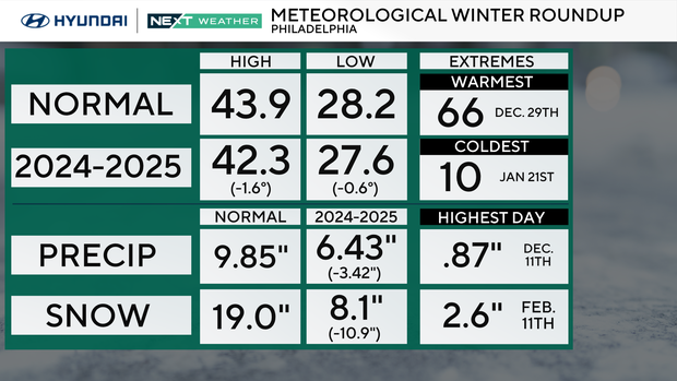
The winter season ended up colder than normal, with both below-normal averages for the highs AND the lows. It's not a record, or even that far off normal, but below nonetheless. The warmest temperature we had was 66 degrees in late December, while the coldest hit just 10 degrees about a month later.
With that being said, the precipitation — or lack thereof — remains the big story. Average precipitation in Philly for those three months is just shy of 10 inches. We had just 6.43 inches this past season, a whopping 3.42 inch deficit, but that doesn't tell the whole story.
If we go back to Sept. 1, our total deficit is a staggering -10.91 inches, nearly a FOOT below normal. Not snow, but rain! That's why the area remains in an extreme drought and fire danger will continue to be very elevated. As for snow, we only had 8.1 inches, when the normal snow for the period is 19 inches, thus adding insult to injury in both the drought situation and for snow lovers.
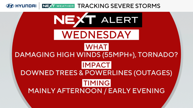
NEXT Weather Alert in effect for Wednesday
Tuesday will be another rain-free day, but temps will rebound to the mid to upper-50s with increasing clouds ahead of a vigorous spring storm system. While we will see more cloud cover on Tuesday, it'll be a pretty decent day with warmer air and a gusty breeze developing in the afternoon.
Wednesday is a NEXT Weather Alert Day for the possibility of heavy rain and severe storms. Gusty southwest winds will push our temperatures to the low 60s, and by late afternoon and evening, a strong cold front will bring strong to severe storms with pockets of heavy rain. The state of Delaware is in a slight (level 2) risk for severe weather on Wednesday, while the rest of our region is in a marginal (level 1) risk.
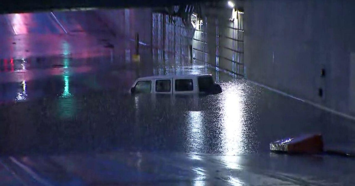
The biggest threat with any severe storm locally will be damaging straight-line winds, although we cannot rule out the potential for an isolated tornado. This line of storms will also bring the likelihood of heavy rainfall, with as much as three-quarters of an inch to 1.5 inches falling over just a few hours, leading to possible ponding and road spray during the Wednesday evening commute. While we do need a good soaking rain, the timing is less than ideal.
Philadelphia weather forecast for the rest of the week
Behind the storm on Thursday, it's seasonably chilly with a gusty wind that will make it feel much colder. On Friday, we hover near 50 with sunshine and less wind.
Rain showers are once again possible on Saturday.
Don't forget, daylight saving time begins next Sunday morning, so flip the clocks ahead one hour next Saturday night and change the batteries in your smoke and carbon monoxide detectors.
Speaking of Sunday, models are in massive disagreement about the forecast weather pattern, although one of them wants to cool us down and bring some March snow. The NEXT Weather Team will keep you posted ahead of the storm!
Here's the 7-day forecast:
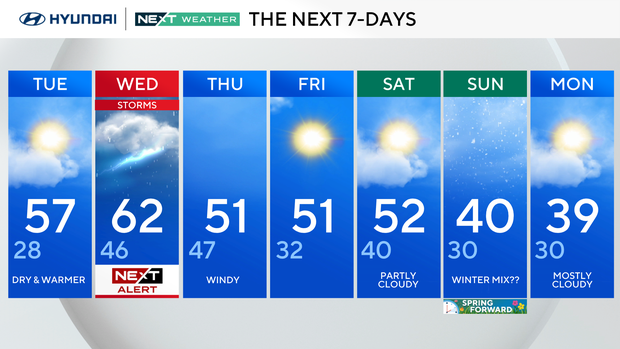
Tuesday: Dry and warmer. High 57, low 28.
Wednesday: NEXT Weather Alert for storms. High 62, low 46.
Thursday: Windy. High 51, low 47.
Friday: High 51, low 32.
Saturday: Partly cloudy. High 54, low 40.
Sunday: Winter mix?? High 40, low 30.
Monday: Mostly cloudy. High 39, low 30.
Get the latest weather info on the CBS News Philadelphia app.