Philadelphia region under winter storm warning as snow, sleet, rain continue to fall. Here's the forecast.


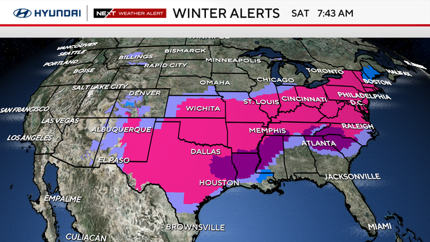
The entire Philadelphia area, from the Shore to the Poconos, continues to be under a winter storm warning through Monday morning for the mix of dangerous winter weather that will cross the area through late Sunday evening.
Depending on your location, this includes sleet, freezing rain, rain and more snow for some.
The sleet and freezing rain are the biggest concerns with this storm. All snow can be plowed and shoveled much more easily than sleet or freezing rain, which creates heavier shoveling, weighs down power lines and tree branches, and can lead to power outages.
Driving is also impacted differently as the precipitation changes. It is dangerous enough on the roadways with heavy snow piling up on the roads. The addition of sleet and freezing rain makes it even tougher.
Latest snow totals in Philadelphia and timeline
Heavy snow began falling across the area between 2 a.m. and 4 a.m. Sunday. The snow fell at a rate of 1-2 inches per hour.
- By 1 p.m., the transition to sleet, freezing rain and rain was underway for large parts of the area.
- 8-12 inches of snow had fallen along the I-95 corridor and throughout southeastern Pennsylvania before transitioning to sleet.
- 4-8 inches of snow had fallen across South Jersey, the Shore and Delaware before transitioning to rain, freezing rain, and sleet, which will taper off by late this evening.
- 10-14 inches of snow had fallen in the Lehigh Valley, Berks County, and the Poconos. Heavy snow was ongoing in these areas and expected to continue through late evening.
Snow totals will be updated throughout the night, and final numbers will be available Monday morning.
This evening, additional snow and sleet will continue to fall across Philadelphia, Chester, Delaware, Montgomery, Bucks, Mercer and New Castle counties.
Moderate snow will continue across the Lehigh Valley, Berks, and Poconos, where little or no sleet developed.
How does this storm rank?
As of 7 p.m., 9.1 inches of snow had fallen at Philadelphia International Airport (the official weather reporting station for Philadelphia).
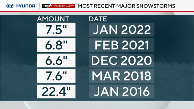
Sunday's snowstorm is Philadelphia's largest since 2016 when it comes to snow accumulation.
How do we currently compare to the top five snowstorms in the past decade?
- 22.4 inches in January of 2016
- 9.1 inches for January 2026
- 7.6 inches in March of 2018
- 7.5 inches in January 2022
We are at the eastern end of this storm that stretched across 34 states from New Mexico to Maine. Nearly 200 million people have been in the path of this rare, major storm.
Why this was a lighter and fluffy type of snow
We are under the coldest air of the season, and any snow that fell had a high snow/water ratio due to the cold. In other words, the colder the air, the more snow was squeezed out.
A 20:1 snow ratio means 20 inches of snow would be produced from 1 inch of water.
So, if there is a half inch of water in the atmosphere, we will see 10 inches. If there is a quarter of an inch of water, we will get 5 inches, and if there is three-quarters of an inch of water, we will see 15 inches.
In comparison, so far this season, we have seen wet snow with ratios of 6:1 and 8:1.
Prepare for continuing impacts of this storm
There's potential for ice accumulation on power lines and tree limbs with this storm.
Possible impacts could include power outages, airport cancellations, train delays, dangerous roads and downed trees. Be prepared for cancellations to religious services, health appointments, fitness or educational programs Sunday and Monday and possibly beyond.
On Sunday, NJ Transit will suspend bus, light rail and Access Link service for the entire day, Gov. Mikie Sherrill announced in a news conference. Train service stopped at 2 p.m. Sunday.
Service on NJ Transit and SEPTA is expected to ramp up slowly on Monday, officials said.
NJDOT lowered the speed limit to 35 mph on Interstate and State highways beginning Sunday at 12:01 a.m.
All School District of Philadelphia schools will be closed on Monday, Jan. 26, Superintendent Tony Watlington said. Students received Chromebooks for potential remote learning days.
NEXT big weather change: Below freezing next 7-10 days
Temperatures will plummet Monday through the middle of next week, with highs in the low 20s and overnight lows dipping to single digits and below zero. So, plan on this snow sticking around for the next 7-10 days. We will end January and start February bitterly cold.
The best advice is to stay with the NEXT Weather team for frequent updates each day to plan and prepare for the weekend. Have the shovels and ice melt ready. This could be the biggest snow of the season.
Where to find warming centers around Philadelphia
Philadelphia has activated an Enhanced Code Blue due to the extremely cold temperatures. The city activates an "enhanced" alert when a Code Blue lasts more than three nights in a row. Because of the enhanced alert, the Office of Emergency Management has opened multiple warming centers throughout the city.
The centers are free and open to the public. People who need help or see someone in need of help during this cold weather event can also call 215-232-1984.
Bucks County issues a Code Blue whenever temperatures drop below 20 degrees, but could also issue the alert based on other cold-weather factors. Information about shelter openings can be found on the Housing Link website.
Residents who need temporary shelter, food and clothing during the winter can call 211 or text their zip code to 898-211 for immediate assistance.
During a Code Blue, residents in need of shelter are encouraged to visit one of Delaware County's weather advisory relief centers.
During a Code Blue, the county has additional resources for people experiencing homelessness, including access to temporary warming shelters, food and clothing. Anyone who needs help with temporary shelter during the cold can call the Your Way Home Call Center at 610-278-3522.
New Jersey
Active Code Blue declarations are listed by county on New Jersey 211's website.
The site also includes a list of available warming centers in each county.
Delaware
In Delaware, Code Purple Shelters can provide emergency housing during severe winter weather. Shelters for the state's counties can contact at the following numbers:
- New Castle County – 302-652-8033
- Kent County – 1-800-733-6816
- Sussex County – 302-519-0024
- Or call 2-1-1
Here's your 7-day forecast
Sunday: NEXT Weather Alert for snow and ice. High 25, Low 14
Monday: NEXT Weather Alert continuing snow impacts. High 27, Low 24.
Tuesday: Very cold. High 23, Low 12
Wednesday: Deep freeze. High 24, Low 12
Thursday: Very cold. High 24, Low 12
Friday: Cold but sunny. High 27, Low 13
Saturday: NEXT Weather Alert Staying cold. High 27, Low 14