Expect soggy weather Saturday night across the Philadelphia region. Here's the weekend forecast.

Saturday's weather around the Philadelphia will feature some rain, but not until later this afternoon. After a warm start to the day for September standards — with temperatures in the upper 60s — cloud cover will continue to stream into the region as we go throughout the day.
Skies will eventually become mostly cloudy by early this afternoon as light showers begin to move in from the south.
Light showers at first will turn into more widespread showers with pockets of heavy rain as we head into the late evening and overnight hours.
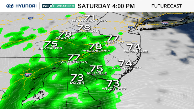
Even a few thunderstorms will be possible across the southern half of the region from the Delaware Valley to the Shore, but severe storms are not expected.
That said, there will be pockets of heavy rain within some of the thunderstorms. Rain totals will range from about 0.25 inches to 0.50 inches with the higher totals likely south of the I-95 corridor.
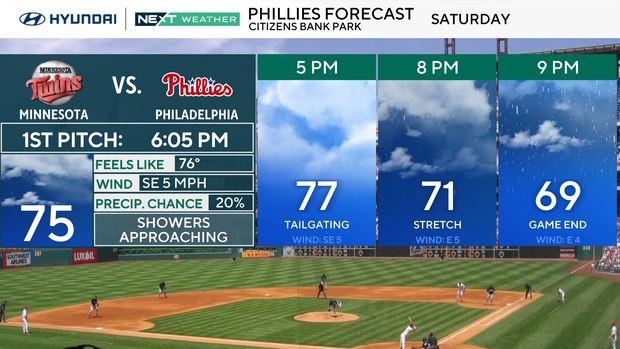
Showers will be approaching when the Phillies throw the first pitch Saturday night at Citizens Bank Park against the Minnesota Twins.
The rain will clear out before sunrise Sunday morning with the clouds following suit. Temperatures Sunday will be similar to Saturday, with highs near 80 degrees under partly cloudy skies.
Cloud cover and slightly warmer than normal temperatures hang around through early next week, but right now it likes the rain will stay away. A push of drier and more fall-like temperatures are set arrive through the middle and second half of the week.
Wednesday temperatures will only climb into the low 70s and then on Thursday, high temperatures in the afternoon will struggle to climb out of the 60s under mostly sunny skies.
Tracking the tropics
In the meantime, the NEXT Weather Team is keeping an eye on the tropical and two tropical systems in the Atlantic. Hurricane Humberto rapidly intensified to a Category 4 storm this morning just northeast of the Caribbean.
Another developing tropical system, "Potential Tropical Cyclone Nine," is organizing just south of the Bahamas.
Humberto is forecast to become a category 5 hurricane later today as it tracks toward Bermuda and then curves northeast into the north Atlantic next week.
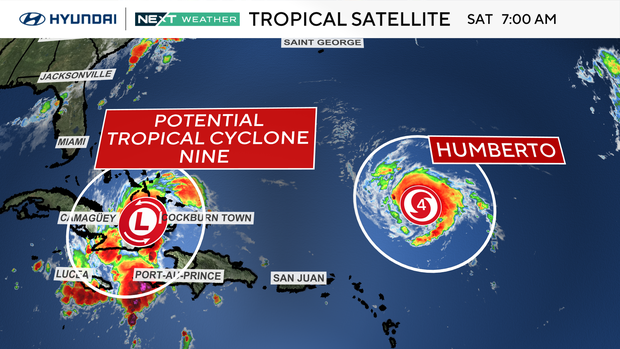
Potential Tropical Cyclone Nine, however, is expected to gradually develop, becoming Imelda, and track north toward the Southeast coast of the United States through early next week.
At this time, the Philadelphia area does not look to have any direct impacts from either system, but the NEXT Weather Team will continue to monitor both systems as we head through next week.
Here's your 7-day forecast:
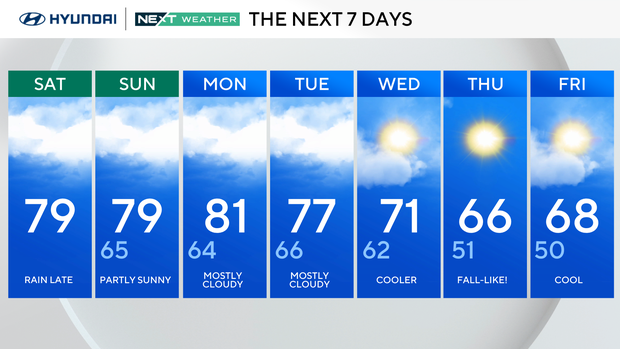
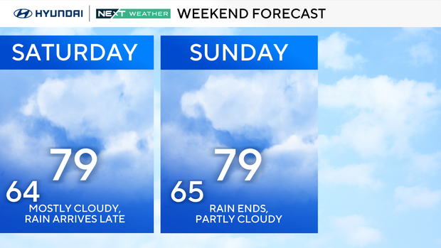
Saturday: Rain at night. High 80, Low 64.
Sunday: Mostly cloudy. High 79, Low 65.
Monday: Mostly cloudy. High 81, Low 64.
Tuesday: Mostly cloudy. High 77, Low 66.
Wednesday: Cooler. High 71, Low 62.
Thursday: Cool! High 66, Low 51.
Friday: Partly cloudy. High 68, Low 50.


