Humid, warm Wednesday in Philadelphia region, tracking more rain this week. Here's the weather forecast.
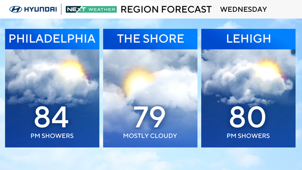
Our unsettled and unseasonably warm start to fall in the Philadelphia region will continue Wednesday with some more relatively warm weather, including humid air and mostly cloudy skies.
Before then, we're dealing with dense morning fog. We've issued a NEXT Weather Alert as visibility is less than a quarter mile in spots, and the National Weather Service just issued a dense fog advisory as well for east central and southeast Pennsylvania.
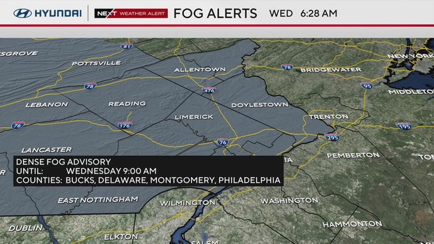
This advisory lifts at 9 a.m. Sunlight will burn off the fog but it will take time. Remember if you are driving in fog to slow down, turn on your headlights (not your high beams), proceed with caution and allow extra car lengths between your car and the one in front of you.
and then a wave of energy will likely push through the area on Wednesday evening, bringing another round of showers and storms to the Delaware Valley.
At this point, we are not under any severe risk, but any lightning, regardless of the strength of the storm, is dangerous. Be looking out and listening for thunder, especially during the later evening hours.
Thursday looks like more active in terms of precipitation, a wet day with scattered rain in the morning through midday and then a chance for storms with rumbles of thunder and heavier rain in the evening.
The Storm Prediction Center has our area under a level 1 risk at this time for Thursday, with damaging wind gusts being the most likely possibility for severe weather.
Friday and beyond look to be trending generally dry, but a pop-up shower or two aren't out of the question as humidity levels will remain high for this time of year, along with above-normal temperatures.
Gabrielle continues to be a major hurricane with sustained winds of 125 mph, making it a Category 3 storm. It will move east, so no direct landfall impacts, but the rough surf will likely continue this week.
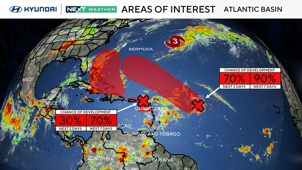
In addition, the National Hurricane Center has identified an additional two areas of interest, both of which have a 70-90% chance of becoming named storms. While the trajectory has both areas headed toward the U.S. Eastern seaboard, the longer term forecast models push them back out into the Atlantic with paths similar to Erin and Gabrielle.
Your NEXT Weather Team will keep you posted.
Here's your 7-day forecast:

Wednesday: Mostly cloudy. High 84, Low 66.
Thursday: Rain, thunderstorms. High 80, Low 71.
Friday: Clouds, sun. High 80, Low 69.
Saturday: Clouds, sun. High 81, Low 65.
Sunday: Mostly sunny. High 84, Low 65.
Monday: Trending dry. High 81, Low 62.
Tuesday: Partly sunny. High 72, Low 59.