Cloudy and mild Tuesday in Philadelphia, tracking cooler temps later this week. Here's the weather forecast.
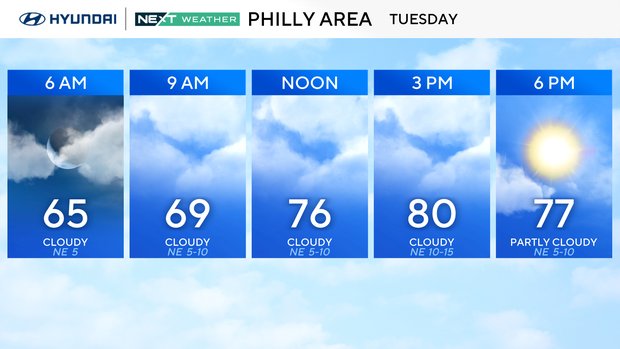
Tuesday will start out with cloudy, muggy and mild weather in the Philadelphia area, but by the end of the day, the sun will appear and the temps should rise into the low 80s again.
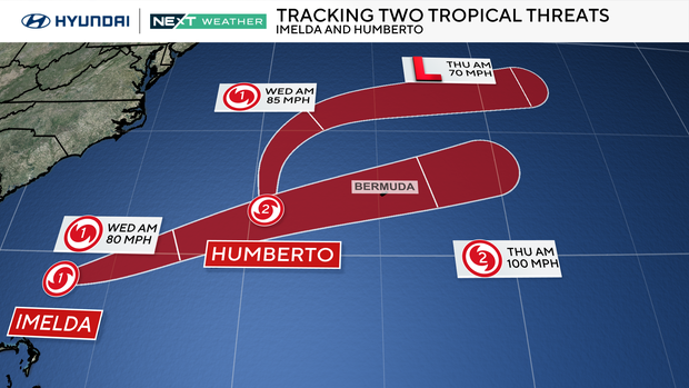
Meanwhile, we're tracking both Humberto and Imelda in the Atlantic. Imelda has strengthened to a hurricane as it starts to be pulled out to sea by Humberto's circulation. Imelda may pass over Bermuda by early Thursday as a Category 1 or 2 hurricane while Humberto weakens to the north.
One thing to note: rip currents and rough surf will be felt on and along all beaches and shore points. Boaters should proceed with caution and pay attention to any alerts that may be issued.
In our area, we are watching a dry cold front that will finally bring some fall weather to the region just in time to start October. That front moves through Tuesday night, bringing in a fresh north wind and knocking temperatures back.
Wednesday feels like fall, with highs around 70 and a gusty breeze as Canadian high pressure builds in. That high will lock in cooler, dry weather through the end of the week. By the weekend, the air mass moderates and temperatures gradually climb back toward the 80 mark.

The extended forecast remains dry, and temperatures stay well above normal after the brief midweek cooldown.
Here's your 7-day forecast:
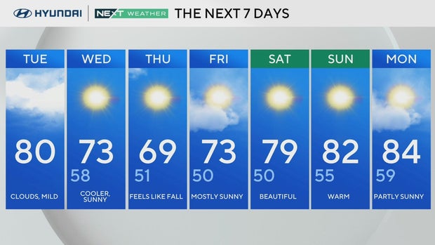
Tuesday: Cloudy skies. High 80.
Wednesday: Turning cooler. High 73, Low 58.
Thursday: Feels like Fall. High 69, Low 51.
Friday: Sunny, nice. High 73, Low 50.
Saturday: Beautiful. High 79, Low 50.
Sunday: Sunny. High 82, Low 55.
Monday: Partly sunny. High 84, Low 59