Dry but windy Friday in Philadelphia region, 2 winter storms in the forecast. Here's what to expect.
Friday morning fog is pushing out of the Philadelphia region to the south.
It will be the break day between weather systems that will continue to bring wintry conditions. While Friday brings a break in the precipitation, there will be gusty winds with the passing of a cold front set to cool us down for Saturday, setting the stage for that second round of winter conditions.
If you're driving anywhere Saturday night into Sunday morning, use caution as roads could be snowy or icy.
Here's what it looks like at this point:
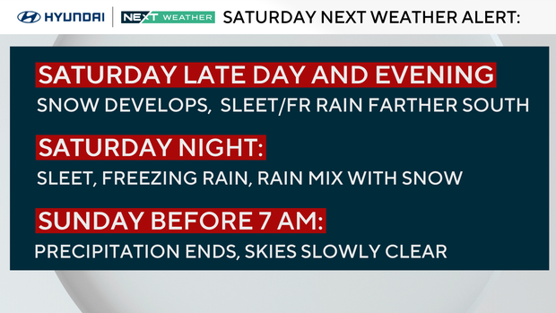
- Precipitation starts Saturday afternoon/early evening in the form of snow, working in from southwest to northeast.
- By the late evening hours, the snow transitions to sleet and some freezing rain from south to north.
- Overnight, the precipitation will begin to taper off, with spots south of Philly getting all rain after the initial onset, while the Lehigh Valley and Poconos may remain mostly snow, thus higher totals.
- It's not a big snowmaker, with the greatest totals being 3 to 6 inches on the extreme high end.
- It will, however, create messy travel Saturday night, so be aware if you're heading out.
On Sunday that weather system moves out and we have a dry day to watch the Birds in the Super Bowl.
Temps on Sunday and Monday will be chilly, with highs in the upper 30s.
Then, we move to next week, where a series of potentially significant snow events may impact our area. The first will be Tuesday afternoon or evening into Wednesday morning, then another wave or two Thursday and Friday, with a major storm system setting up for the following weekend that could have wide-reaching impacts. It's way too far out to tell any details on that one but it bears watching.
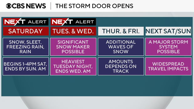
As for Tuesday and Wednesday, we are on another NEXT Weather Alert watching the potential for heavy snow.
If things materialize, we could be looking at widespread impacts Wednesday, including the chance of school closures and delays. We'll keep you updated.
Super Bowl forecast in New Orleans, Philadelphia
In New Orleans, fans will enjoy the game in the dry, temperature-controlled Superdome. Outside temperatures will be in the 70s to near 80 with dry conditions.
In Philadelphia, the storm will be clearing out, making for a quiet day with a high of 39.
Here's the 7-day forecast:

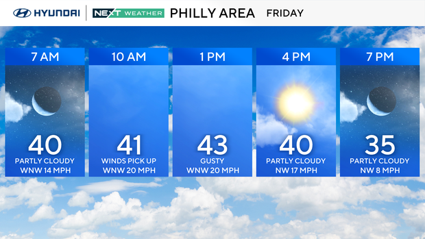
Friday: Sun, breezy. High 44, low 37.
Saturday: NEXT Weather Alert for snow/mix. High 33, low 23.
Sunday: Clearing to sun. High 39, low 29.
Monday: Clouding up. High 39, low 27.
Tuesday: NEXT Weather Alert for snow. High 35, low 25.
Wednesday: NEXT Weather Alert for snow/rain. High 36, low 30.
Thursday: Wintry mix. High 38, low 32.
Get the latest weather info on the CBS News Philadelphia app.