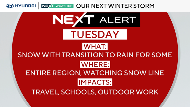
When does the snow start in Philadelphia area this week? Here's the NEXT Weather forecast.

Monday will be mainly sunny but cold and brisk in Philadelphia. Temperatures in the afternoon will remain cooler than normal for the first day of December, with highs in the low 40s. If you're heading out, make sure you've got the heavy coats.
What's NEXT
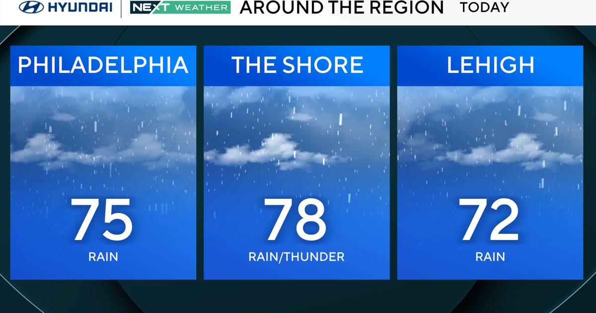
A storm system will pull out of the south tonight and start to spread precipitation in our direction overnight. Many areas from the I-95 corridor to the north and west will see snow arrive early Tuesday with a gradual transition to rain through the late morning.
The snow looks to hang around longer north and west of the city, allowing a little more snow to accumulate before the precipitation changes over to all rain, melting the snow that fell earlier in the day.
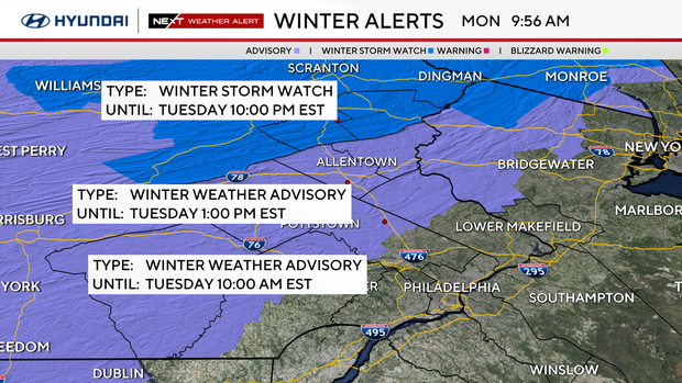
Areas in upper Bucks, upper Montgomery and into Lehigh, Northampton counties will have a better chance of receiving all snow, allowing for accumulations of between 1 and 3 inches. The Poconos could pick up between 4 and 8 inches of snow through Tuesday.
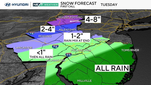
It's important to note that the details of the forecast will likely change due to some remaining uncertainty in the exact track of the storm system. A shift to the north could bring warmer air, reducing the amount of snow. On the other hand, a change in the track to the south would allow for a little more snow in some regions.

Tuesday morning will be heavily impacted by this storm system, which will make for some rough travel through at least the first half of the day. The system will then pull away Tuesday night, with temperatures dropping back into the 20s, which will produce the concern for black ice for the morning commute Wednesday.
The remainder of the week remains well below normal with chilly temps. A push of even colder air Friday will hold temperatures below freezing for most of the day before another system brings the chance for winter weather to move through the region next Saturday.
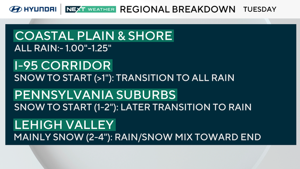
Snow forecast by region
- New Jersey coastal plain and shore: A few snowflakes possible before sunrise Tuesday, but transition to mainly a cold rain for the remainder of the day. Rain ends around sunset.
- I-95 corridor: Starts as snow or a rain/snow mix before sunrise (less than 1 inch of snow). Precip transitions to all rain by mid-morning and remains all rain, melting any earlier snow. Rain ends just before sunset.
- Pennsylvania suburbs: Starts as all snow before sunrise and remains snowing through mid-morning (1-2 inches). Precip transitions to all rain by midday and remains mainly rain. Earlier snow mostly melts. Rain ends just before sunset.
- Lehigh Valley: Starts as all snow before sunrise and remains mostly snow through the day (2-4 inches).
- Poconos: Snow arrives a couple of hours before sunrise. Snow showers continue all day (4-8 inches). Snow ends through mid-afternoon.
Here's your 7-day forecast:
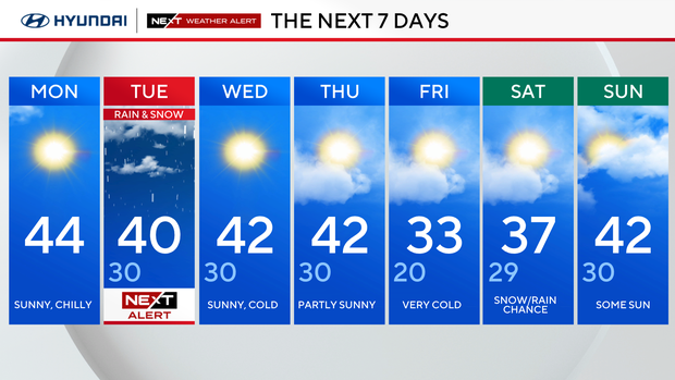
Monday: Sunny and breezy. High 44.
Tuesday: NEXT Weather Alert for snow and rain. High 40, Low 30.
Wednesday: Sunny, cold. High 42, Low 30.
Thursday: Partly sunny. High 42, Low 30.
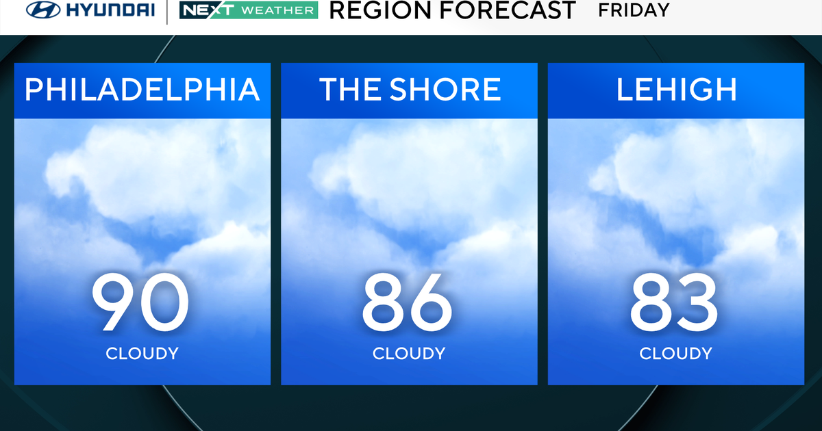
Friday: Coldest yet. High 33, Low 20.
Saturday: Snow and rain. High 37, Low 29.
Sunday: Some sun. High 42, Low 30.