How much rain will the Philadelphia region get Wednesday? Here's the weather forecast.
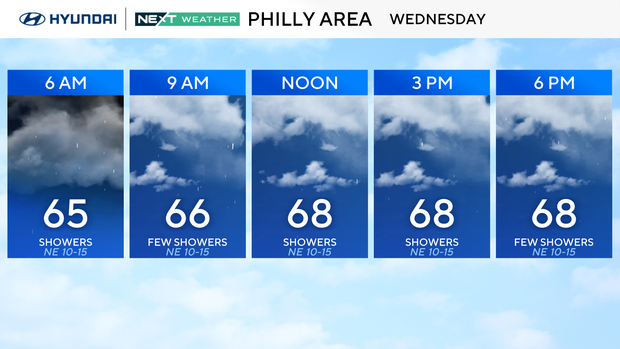
A slow-moving coastal system continues to impact the Philadelphia area's weather on Wednesday, bringing clouds, showers, below-normal temperatures and breezy to windy conditions.
Showers have largely stayed south today but will continue lifting north through the afternoon, even as the coverage diminishes. We can't rule out a fumble of thunder in some spots.
We could see scattered showers throughout the day. Overall rainfall totals will range widely, from areas to the west picking up a tenth of an inch or so. Other parts of South Jersey may get 1-2 inches of rain.
No flood alerts are in effect at this time, but your NEXT Weather team will continue to update any changes.
Winds will also continue to gust 25 to 35 mph during the day Wednesday, mainly closer to shore locations.
By midday Thursday, the system moves away, leading into a drier stretch. Temperatures surge into the mid-80s on Friday before a backdoor front knocks us back to the 70s over the weekend.
Here's your 7-day forecast:
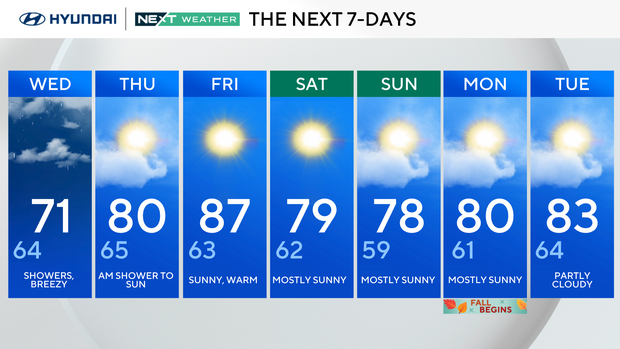
Wednesday: Showers, breezy. High 71, Low 64.
Thursday: A.M. shower to sun. High 80, Low 65.
Friday: Sunny, warm. High 87, Low 63.
Saturday: Mostly sunny. High 79, Low 62.
Sunday: Mostly sunny. High 78, Low 59.
Monday: Mostly sunny. High 80, Low 61.
Tuesday: Partly cloudy. High 83, Low 64.