Cloudy Monday in Philadelphia region before rainstorms later this week. Here's the weather forecast.

Monday will start off sunny and beautiful, with increasing clouds by the afternoon. The clouds that will move in are on the northern fringe of what will be a pretty dynamic system to move up the East Coast this week, providing unsettled weather Tuesday through at least the first half of next weekend in the Philadelphia region.
Monday will remain unseasonably warm in the low 80s with increasing clouds throughout the day ahead of a large storm system tracking northward from the Gulf Coast.
Overnight, expect partly cloudy skies and mild temperatures.
A sprinkle is possible early Tuesday, but by the afternoon, scattered showers and storms roll in. Temperatures will tumble to the upper 60s on Tuesday and Wednesday. We finally return to the upper 70s by Thursday.
The Gulf Coast storm exits on Thursday, but just as quickly, another system arrives from the west on Friday, bringing more rain and thunderstorm chances through Saturday. Warmth also surges into the area, and highs will climb back to the 80s to end the week.
Here's your 7-day forecast:
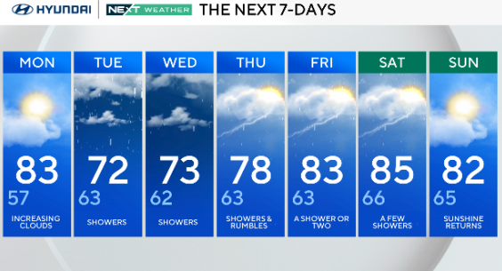
Monday: Increasing clouds. High of 83, low of 57.
Tuesday: Showers. High of 72, low of 63.
Wednesday: Showers. High of 73, low of 62.
Thursday: Showers and rumbles. High of 78, low of 63.
Friday: A shower or two. High of 83, low of 63.
Saturday: A few showers. High of 85, low of 66.
Sunday: Sunshine. High of 82, low of 65.
Get the latest weather info on the CBS News Philadelphia app.


