More storms packed with heavy rain, 60 mph wind gusts moving into Philadelphia area Sunday


We've got it all this weekend! From snow to rain, 60s to 20s, 50-60 mph wind gusts, back ice and snow squalls.
And now another strong winter storm will cross the area Sunday.
The Delaware Valley will be in the warm sector much of the day with gusty south winds pushing our temperatures to the 50s and 60s.
Showers and a few gusty thunderstorms will reach the region in the late morning to late afternoon ahead of a very strong cold front. Periods of heavy rain are possible with localized flooding.
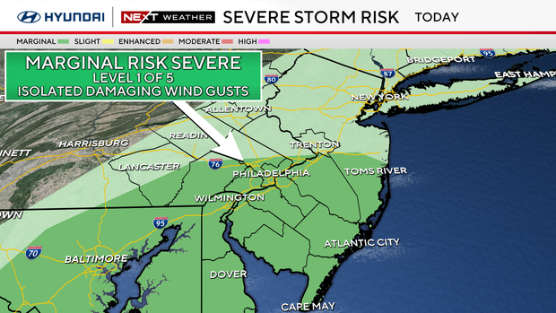
From I-95 south and east there is a low-end threat of brief damaging wind gusts with some of the storms.
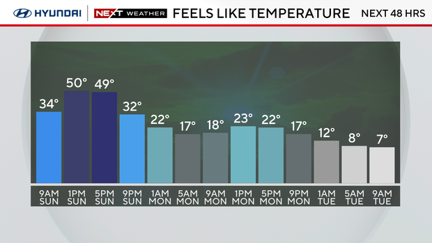
Following the passage of the cold front, temperatures will begin to plummet from near 60 to the 20s just after midnight. That's a very sharp drop in less than 12 hours.
Any standing water will refreeze, so expect black ice on roads and surfaces Monday morning.
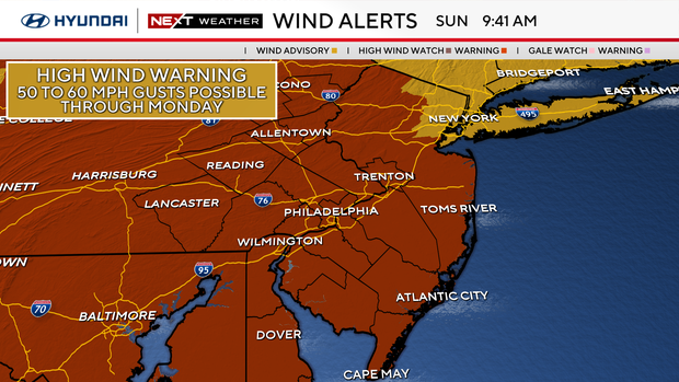
Strong winds will develop behind the storm this evening with gusts between 40-60 mph. These winds will continue through Monday, and a high wind warning remains in place for the entire Delaware Valley until 6 p.m. tomorrow.
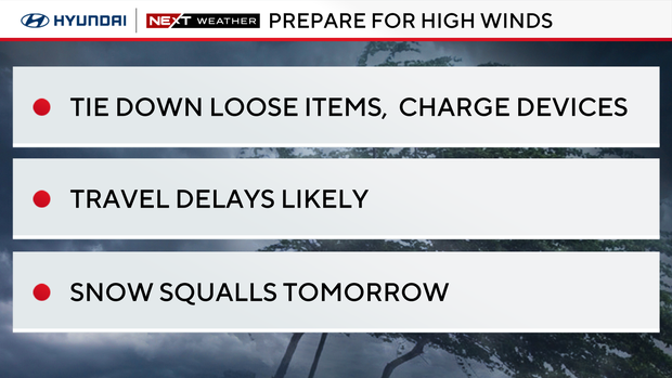
Now's the time to secure any loose items outside. The high winds could bring down trees, tree branches, and powerlines. Power outages are possible.
Some flights are delayed at Philadelphia International Airport, and Amtrak train service between Philadelphia and Wilmington is also delayed. Gusts up to 71 mph have been reported in Atlantic City.
Due to the sharp drop in temperatures, any loss of power could leave you in a deep freeze.
Frigid Presidents Day forecast
Presidents Day on Monday will be partly sunny, very windy and cold. Highs will be in the mid 30s, but the wind chill will feel like the 20s.
The strong west-northwest winds may also usher in scattered lake effect snow showers and snow squalls.
Temperatures dip even further Tuesday through Thursday. We will likely remain below freezing all three days with lows in the teens and 20s and highs only in the 20s.
Another winter storm arrives Wednesday night and Thursday, which could possibly be a significant snow maker for our area.
Details will come into better focus by early in the work week so stay tuned. The NEXT Weather Team will be tracking this storm and keep you updated.

Here's the 7-day forecast:
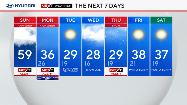
Sunday: NEXT Weather Alert for rain and wind. High 59.
Monday: NEXT Weather Alert for blustery weather. High 36, low 26.
Tuesday: Sunny and very cold. High 29, low 19.
Wednesday: Snow late. High 28, low 16.
Thursday: NEXT Weather alert for snow. High 29, low 19.
Friday: Partly sunny. High 38, low 21.
Saturday: Mostly sunny. High 37, low 19.
Get the latest weather info on the CBS News Philadelphia app.


