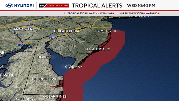
Hurricane Erin triggers tropical storm warning for New Jersey, Delaware beaches. Here's the weather forecast.
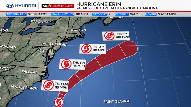
Hurricane Erin is still churning north and on track to pass by the Jersey Shore and Delaware beaches hundreds of miles off the coast. While the heart of the storm will likely stay well offshore (fortunately), we will have several impacts locally.
Here are a few of those impacts:
- High rip current risk will continue through at least Friday.
- Long-period swells will generate rough surf and large breaking waves through Friday night
- 6-12 foot seas on Thursday.
- Dangerous swimming and boating conditions all week.
- Beach erosion is likely.
- Coastal flooding is a possibility, especially at high tide, through Saturday.
- Flood advisories and watches are in effect.
- Tropical storm warning in effect through Thursday night.
- Spotty showers from the farthest rain bands clipping the shore.
We've issued a NEXT Weather Alert for shore towns on Thursday due to these impacts.
Winds will also pick up at the Jersey Shore through the day Thursday, with gusts up to 45-50 mph. A Wind Advisory will take effect at 10 a.m. and is set to expire at midnight.
Away from the coast, impacts from Erin will be limited. The bigger story Thursday will be the cool and cloudy pattern that we'll be stuck in through at least the first half of the week — highs only in the 70s with limited sun and the chance for spotty showers.
A cool breeze will make it feel more like fall than August. We'll start to brighten up and warm up by the end of the week, into the weekend as Erin moves away.
After Thursday, weather conditions will improve dramatically. In fact, Friday and Saturday are looking gorgeous with warmer conditions, highs in the 80s under sunny skies, and low humidity.
Sunday is trending drier but still tracking a chance of showers and partly cloudy skies.
Here's your 7-day forecast:

Thursday: NEXT Weather Alert for Hurricane Erin's effects. High 74, Low 64.
Friday: Sun returns. High 83, Low 61.
Saturday: Sunny. High 83, Low 61.
Sunday: Partly cloudy. High 83, Low 67.
Monday: Shower or rumble. High 83, Low 68.
Tuesday: Mostly sunny. High 79, Low 63.
Wednesday: Mostly sunny. High 78, Low 59.