Severe thunderstorms hit Philadelphia region, disrupt July 4 events. Here's the weather forecast.

The NEXT Weather team is tracking severe storms that are disrupting festivities in the Philadelphia area, including July Fourth fireworks.
The July Fourth concert on the Benjamin Franklin Parkway in Philadelphia is paused because of the weather.
A severe thunderstorm warning is in effect in Burlington, Monmouth and Ocean counties until 10:45 p.m.
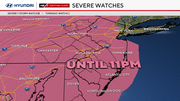
A severe thunderstorm watch was in effect across the region but has expired.
Thousands of customers are without power as the storms bring strong winds to the region.
Managing hot weather
You need to, once again, massively prepare for the heat if you are going to be outside for any length of time. Ice cold waters, cold towels, Hats, umbrellas (for the shade), a fan (battery-powered if possible) and light-colored, lightweight, loose-fitting clothing.
Take the heat seriously; we've already seen numerous heat-related injuries across the Tri-state this week.
The heat has already thrown a wrench into Philadelphia's July Fourth celebrations as the city's Salute to Independence Semiquincentennial Parade in Old City was canceled on Friday.
In addition to the heat, keep your eyes to the skies and ears up listening for thunder. Storms will likely be popping up around the region come late afternoon/early evening and some may be strong to severe.
Our greatest risks are lightning, heavy rain and gusty winds. If you hear thunder, you must get out of the pool, and under cover as lighting can be deadly and come up quickly.
Also, best to stay out of the tub and/or showers during a lightning storm as well.
Plan and prepare for the heat
Saturday is a day that will likely have many people outside, especially during the peak heat, because it falls on the Fourth of July with the final 2026 Men's World Cup match at Philadelphia Stadium.
It's important to stay hydrated and be mindful of things like headaches, fatigue and dizziness. Those symptoms are all signs that you are entering into heat-related illnesses, and you'll need to cool down immediately.
Have somewhere cool to rest, special care for pets, check on neighbors and family, limit time outdoors, check fluid in cars and keep hydrated.
Swimming pools, movie theaters and shopping malls are places to stay cool.
Cars become death traps in the heat. No people or pets should ever be left in the car. The heat can reach 125 degrees in minutes and cause death. Check your back seat before leaving a car.
Buildings with no air conditioning will heat up and retain the heat. That cumulative effect of the heat after three to five days could be deadly for some.
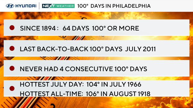
Our heat records since 1894
- There have only been 64 100-degree days in Philly since 1894 (per the NWS).
- We've had only one 100-plus-day in 14 years. That was last June 24, 2025.
- The hottest day on record for Philly is 106 on Aug. 7, 1918.
- The hottest July temperature on record is 104 on July 3, 1966.
- Back-to-back 100-degree days have only occurred 14 times. The last back-to-back 100-degree days were in July 2011.
- Three consecutive 100-degree days have only happened twice in Philly history, during July of 1993 and July of 1966.
- We have never had four consecutive 100-degree days.
- The July 3 record is 104 from 1966.
NEXT big change
We will start to see a change in the overall pattern beginning Sunday, with high temps remaining below the triple digits but still very hot and humid.
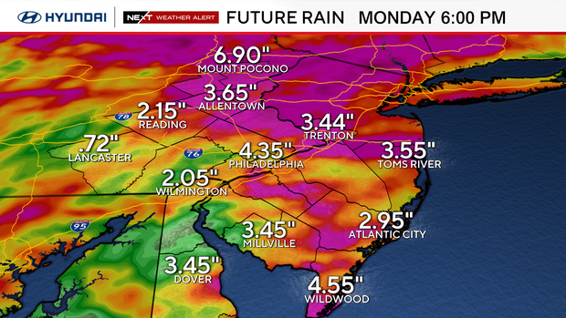
Storms will likely be more widespread on Sunday, especially during the evening as our overall setup for the heat begins to break down and a front approaches the area.
That front brings very unsettled weather from Sunday through Tuesday, but it also knocks our temps back into the mid-low 80s (perhaps cooler) to start your workweek. By mid-late week temps go back to near 90°. Good, hot summer weather but nothing extreme.
Looking ahead
We are looking ahead to Monday for a noticeable break in the heat. Highs drop to the 80s, and with more showers and storms, Tuesday may even struggle to hit the 80-degree mark.
It will be a big change from the record high temps we are experiencing now.
Here's your 7-day forecast:
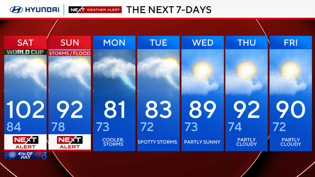
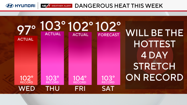
Saturday: NEXT Weather Alert. High 102, low 84.
Sunday: NEXT Weather Alert: High 92, low 78.
Monday: Cooler, storms. High 81, low 73.
Tuesday: Spotty showers. High 83, low 72.
Wednesday: Partly sunny. High 89, low 73.
Thursday: Partly cloudy. High 92, low 74.
Friday: Partly cloudy. High 90, low 72.


