Strong winds and flooding will be possible today for the Pittsburgh area

Strong winds and flooding will be possible today throughout parts of the Pittsburgh area.
Any Alert Days Ahead? Today and Tuesday are First Alert Weather Days due to a severe weather risk. Strong winds and flooding are the main threats. A tornado and large hail are also possible. Tuesday is also a FAWD due to severe weather and flooding.
Aware: In the first 9 days of the month, Pittsburgh has recorded 3.32 inches of rain. The average rain total for August in Pittsburgh is just 3.52" of rain.
Dry days have been pretty rare recently in Western Pennsylvania. Yesterday was only the 2nd dry day of the month. We did have a third day with just a trace amount of rain. When you add up the rain totals, the Pittsburgh airport has recorded 3.32 inches of rain so far this month. The average for the entire month is 3.52". If we don't see enough rain to put us above the average today, it's almost a sure thing we will be there before the end of Tuesday.
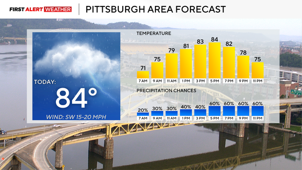
The biggest issue today will be storms racing from the west to the east below the jet stream. Wind speeds of 60 to 70 mph will be possible on the leading edge of any storms rolling through. Frequent lightning and downpours should also be expected with any storms. Tornados and large hail can't be ruled out with any storms that begin to rotate.
Strong storm chances stick around on Tuesday as well. Similar to today, there will be large gaps of three to four hours between rounds of rain so the day won't be a washout. The issue is with humidity levels and precipitable water values in the high range, and storms that develop will drop a lot of rain in a short amount of time. Our storm chance dips to near zero for the rest of the work week after storm chances come to an end early on Wednesday morning.
High temperatures today will hit the mid-80s. Noon temperatures will be near 80 degrees. The severe risk will be highest from 1 p.m. today to 1 a.m. on Tuesday morning. Tuesday's storm chance arrives a little earlier, around 10 a.m., and continues through Wednesday morning. Non-storm winds today will be out of the southwest at around 10 mph.
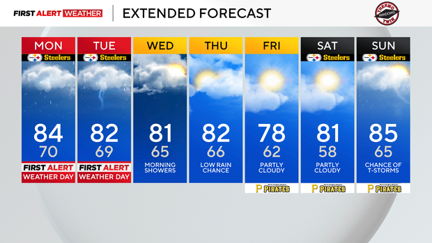
Tuesday highs will be in the low 80s, and the rest of the week will see highs near 80 degrees. Morning lows will slowly drop to the mid and then eventually the low 60s by the weekend.


