Below-freezing temps return to Philadelphia as arctic cold plagues the region. Here's the weather forecast.
The coldest air we have experienced in several years arrived in the Philadelphia area Saturday night following the passage of a strong Arctic front. This air mass comes directly from the Arctic Circle and will be with us through Monday.
The last time temperatures were this low in the city was in 2019. Luckily, there is a warm up on the horizon.
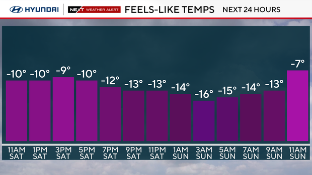
Temperatures behind this front will continue to free-fall from near 30 early Saturday to single digits by Saturday afternoon. Feels-like temperatures will struggle to get above zero at any point this weekend.
Bundle up and be prepared: it will be brutally and dangerously cold night.
The front also brought some snow, and snow squall warnings Saturday morning. Squalls created whiteout conditions in parts of our area in the morning but the alerts have since expired.
Over on our Instagram and TikTok we shared video of a squall blowing snow around Center City Philadelphia.
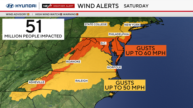
Northwest winds will howl through the day with 40-60 mph wind gusts. The Poconos saw wind gusts of 66 mph while Philadelphia saw 58 mph. That combined with the frigid temperatures will produce dangerous wind chills -15 to -30 degrees all day — and at that level of cold, frostbite can develop within 15-30 minutes.
Even colder wind chills in the Poconos (possibly exceeding -30 degrees) Saturday and Saturday night. The entire region is under an extreme cold warning through 12 p.m. Sunday.
NEXT big change
One other issue we could see this weekend are ice quakes and frost quakes – we've explained more over here.
The winds will taper to 45 mph gusts Saturday night, and the thermometer temperature will get down to the single digits, the first lows in the single digits in our area since 2022. That is rare since there have only been 9 single-digit lows since 2015.
Wind chills will be -10 to -15 degrees.
Sunday morning, we will wake up near 5 degrees in the city, colder away from the city.
The 25 mph wind gusts on Sunday will create a wind chill to -10.
Monday, we will have to watch and see if some schools close or have delayed openings or virtual learning, due to the dangerous cold temperatures. The deep freeze continues to start the workweek with morning lows near 7. Skies will be mostly sunny and afternoon highs will reach the mid and upper 20s.
On Tuesday and Wednesday, we are finally back above freezing with highs in the upper 30s Tuesday and even the low 40s Wednesday.
Here's your 7-day forecast:
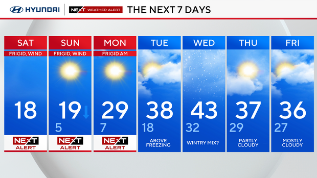
Saturday: NEXT Weather Alert. High 19, low 15.
Sunday: NEXT Weather Alert. High 19, low 5.
Monday: NEXT Weather Alert. High 29, low 7.
Tuesday: Not as harsh. High 40, low 19.
Wednesday: Wintry mix? High 39, low 27.
Thursday: Some sun. High 39, low 31.
Friday: Partly cloudy. High 36, low 27.