First Alert Weather: Timing out this weekend's rain for NYC, N.J. and Connecticut
NEW YORK - The First Alert Weather Team has declared a Yellow Alert for Saturday evening due to the threat of heavy rain and wind.
We have yet another storm system on track for Tri-State impacts starting Saturday afternoon and lasting until early Sunday morning.
Weather Alerts
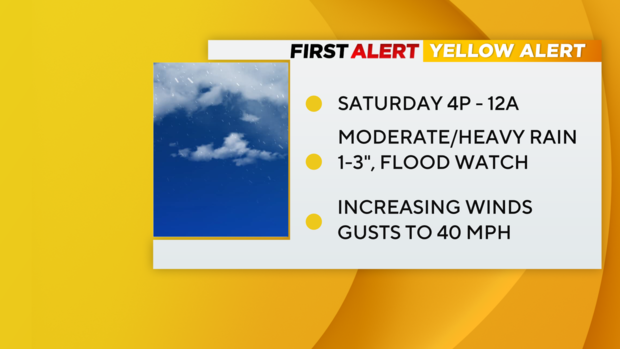
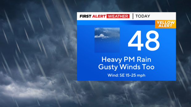
A Yellow Alert is in place from 4 p.m. Saturday through midnight due to the threat of heavy rain and wind.
Flood watches are in place for most of New Jersey, the Hudson Valley and Connecticut through Sunday morning.
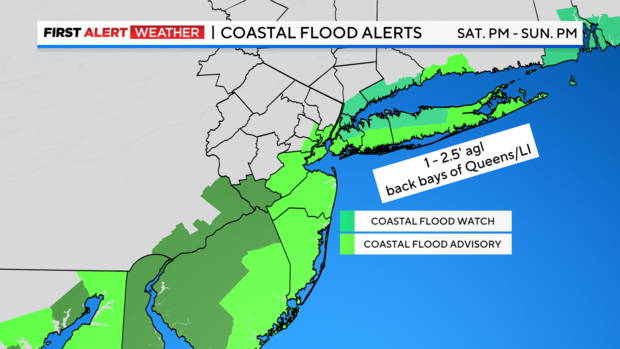
A coastal flood advisory is in place through 12 p.m. Sunday for all of the Jersey Shore, most of the waterways that surround New York City, and the south shore of Long Island.
A coastal flood watch is in place in place for the northern back bays of Queens and Long Island, Westchester, the Bronx, and Fairfield Counties through noon Sunday.
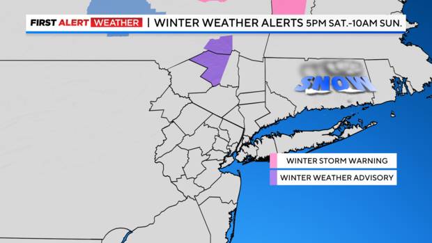
A winter weather advisory is in place for western Ulster County, New York from 5 p.m. Saturday through 11 a.m. Sunday.
Storm Impacts
Flooding: A variety of coastal alerts have been issued, from Statements to Watches, along our shoreline. The most threatening hours would be high tide times Saturday night (approximately 8 p.m.) and Sunday morning (approximately 8 a.m.) for 1 to 2.5 feet of inundation in the back bays of Queens and Long Island, and along shoreline roads. The typical places that swell and flood have a good chance of seeing this happen.
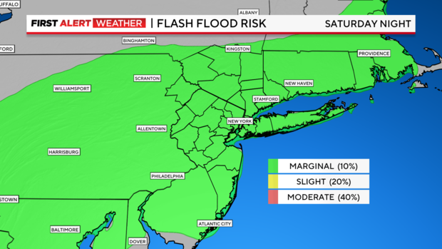
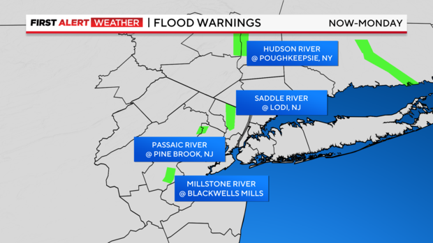
Rivers: Although rainfall looks uniform and not an overwhelming amount, our soil moisture is 80% to 100%, so it takes less rain to trigger troubles. Smaller creeks will swell faster and as of now, no major flooding is expected. All the rivers have receded from Wednesday.
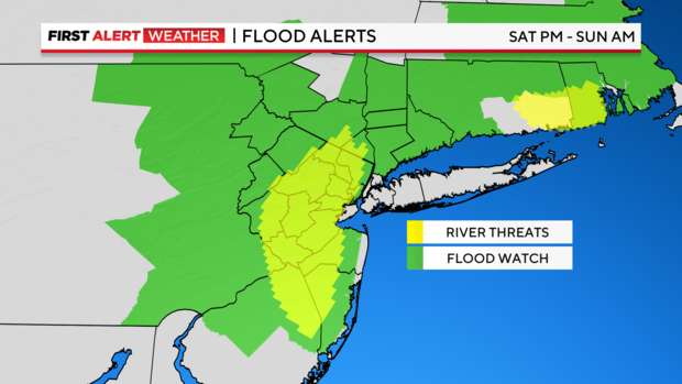
In anticipation of the heavy rain Saturday night, the Weather Service has already issued flood warnings along some of our local rivers.
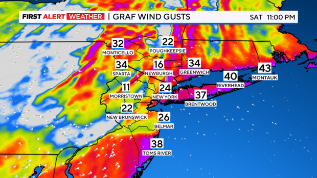
Wind: A factor. Expect breezy conditions Saturday (15 to 20 mph), but after 7 p.m. when the storm shifts into a higher gear (30-40 mph), there is the likely possibility of some tree limbs and unsecured object being scattered about. No advisories right now.
Sunday, the wind shifts and relaxes for a moment before shifting northwesterly and driving our temps down, and even some wraparound snowflakes are not out of the question Sunday into early Monday.
Storm Timeline
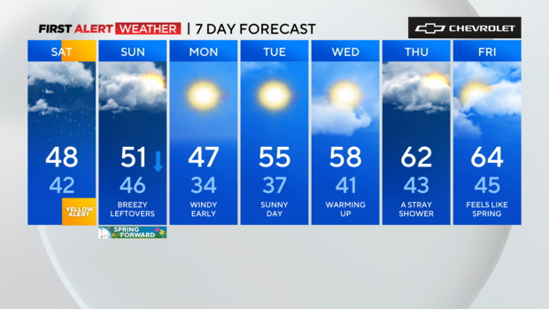
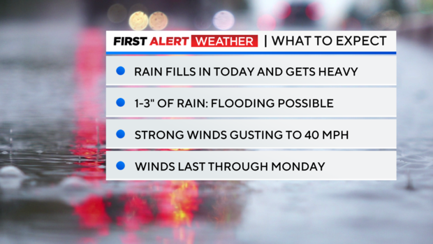
Saturday: Mostly cloudy to start. Rain develops by the afternoon and gets heavy by the evening hours. A few embedded storms are possible too. Winds will ramp up, gusting between 25 and 45 mph. Cool, with highs in the upper 40s.
Saturday 2 p.m. to 6 p.m. - Rain starts to infiltrate the region and becomes progressively heavier as the day wears on. Winds will also begin to get stronger, with gusts between 15 and 25 mph. Some snow is likely for the higher elevations of the Hudson Valley.
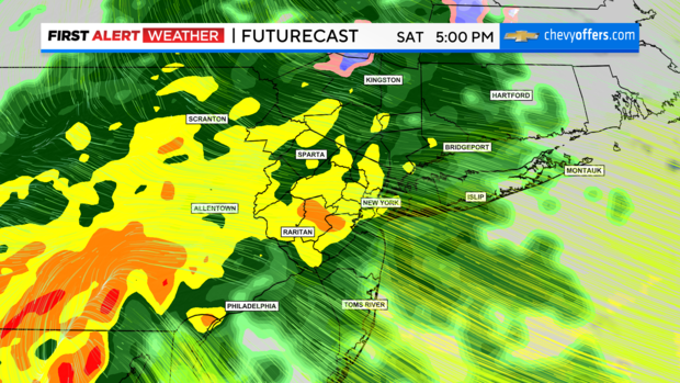
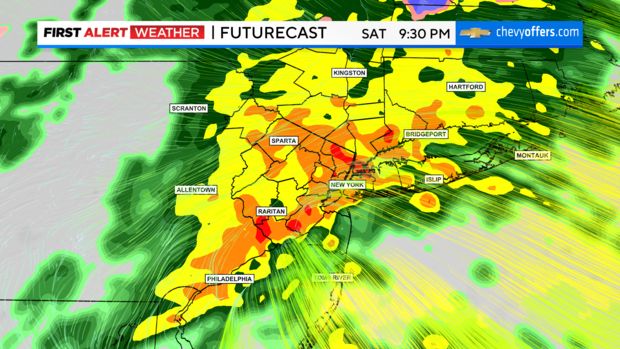
Saturday 6 p.m. to Sunday 1 a.m. - The bulk of the storm. Rain will get very heavy during this timeframe. Some thunderstorms are possible within the heaviest bands of rain. Given the saturated ground from recent heavy rainfalls, flooding will be a concern, especially across the river basins in northern New Jersey that saw some minor flooding from the last storm.
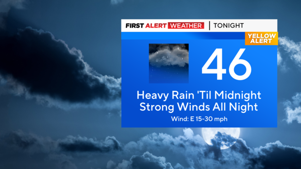
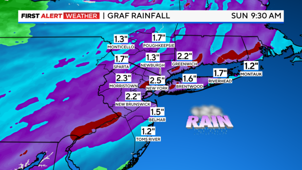
Final rain totals are expected to reach 1 to 3 inches, with isolated higher totals. Winds will ramp up, gusting between 25 and 45 mph at times. Highest gusts are likely at the coast. The saturated ground combined with the strong winds may topple trees. Minor coastal flooding during high tide cycles is also possible as this storm will coincide with the New Moon, which typically causes higher than normal tides. Snow across the higher elevations of western Ulster County may accumulate up to 5 inches.
Rest of Sunday: Most of the rain will be over by 2 a.m., except for eastern portions of Long Island, where it may linger a little longer. Even as the storm departs, winds will remain elevated throughout the day. Gusts between 25 and 45 mph are likely, and some gusts over 50 mph can't be ruled out. A few leftover showers are expected. Some snow showers are also possible once colder air filters into the area. These will mostly be confined to areas north and west of the city though.
Monday: Mostly sunny, but blustery and cold. Highs in the mid to upper 40s. Winds will gust between 40 and 50 mph at times, which will make it feel the 20s and 30s.
Looking Ahead: After the departure of storm Saturday night, a much drier pattern will ensue for the upcoming week. Temps will be a bit cool to start, but gradually trend upwards as the week progresses.