First Alert Weather: Sun returns Friday; Yellow Alert for rain Saturday into Sunday
Alerts & advisories
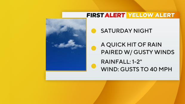
A Yellow Alert is in place for Saturday evening and night due to the threat of heavy rain and wind.
Timing it out
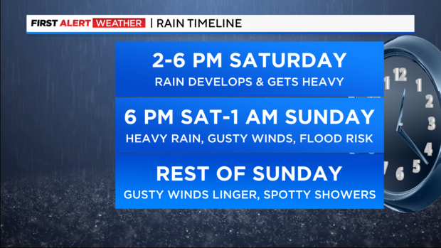
2 to 6 p.m. Saturday: Rain starts to infiltrate the region and becomes progressively heavier as the day wears on. Winds will also begin to get stronger, with gusts between 15-25 mph.
6 p.m. Saturday to 1 p.m. Sunday: The bulk of the storm. During this timeframe, rain will get very heavy. Some thunderstorms are even possible within the heaviest bands of rain. Given the saturated ground from recent heavy rainfalls, flooding will be a concern, especially across the river basins in northern New Jersey that saw some minor flooding from the last storm. Final rain totals are expected to reach 1-2 inches, with isolated higher totals. Winds will ramp up, gusting between 25-45 mph at times. Highest gusts are likely at the coast. The saturated ground combined with the strong winds may topple trees. Minor coastal flooding during high tide cycles is also possible, as this storm will coincide with the New Moon, which typically causes higher than normal tides.
Rest of Sunday: Most of the rain will be over by 2 AM, except for eastern portions of Long Island, where it may linger a little longer. Even as the storm departs, winds will remain elevated throughout the day on Sunday. Gusts between 25-45 mph are likely, and some gusts over 50 mph can't be ruled out. A few leftover showers are expected. Some snow showers are also possible, once colder air filters into the area. These will mostly be confined to areas north and west of the city though.
Monday: Mostly sunny, but blustery and cold. Highs in the mid to upper 40s. Winds will gust up to 45 mph at times, which will make it feel like the 30s.
Weekend forecast
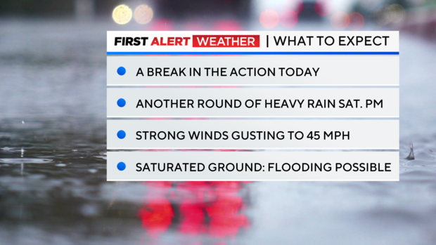
Today: The sun returns, with just a few clouds by the afternoon. Breezy to start, but less wind to end. Mild with highs in the low to mid 50s. Cooler along the immediate coast.
Tonight: Increasing clouds. A low of 42 in the city, and 30s for the suburbs.
Saturday: Mostly cloudy to start. Rain develops by the afternoon and gets heavy by the evening hours. A few embedded storms are possible too. Winds will ramp up, gusting between 25-45 mph. Cool, with highs in the upper 40s.
Sunday: Heavy rain ends by 2 AM. The rest of the day will feature a few leftover rain showers, with some snow showers to the north. Winds remain high, gusting between 25-45 mph. Highs in the low 50s.
Looking ahead
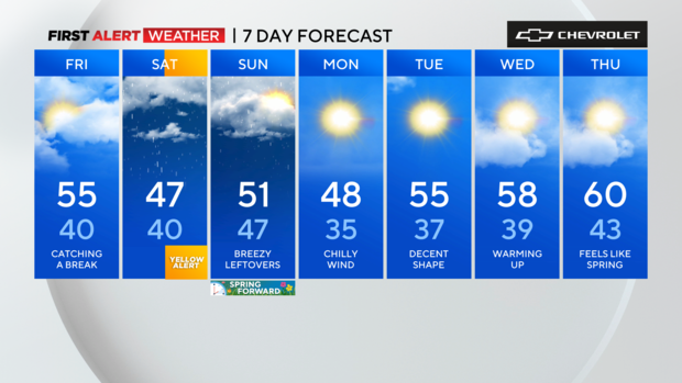
After the departure of storm on Saturday night, a much drier pattern will ensue for the upcoming week. Temps will be a bit cool to start, but gradually trend upwards as the week progresses.
Stick with the First Alert Weather team for the latest forecast and weather alerts.


