Stormy weather returns to NYC area Tuesday after a brief reprieve. Get the First Alert Forecast.
After a brief reprieve, stormy weather will return to the New York City area Tuesday.
It will be a First Alert Weather Day due to the threat of strong-to-severe thunderstorms that may lead to flash flooding.
Once the storm threat diminishes Wednesday night, the rest of the week looks dry with lower humidity. Temperature-wise, highs will generally be in the lower 80s this week, which is below average for late July.
Clouds will gradually increase at night, but we stay dry. Lows will be in the 60s in the suburbs to around 70 in the city.
Another stormy day Tuesday
The stellar weather won't last long, though, as humidity levels and cloud coverage will increase dramatically by Monday night into Tuesday morning.
Much like this past weekend, any storm could be strong to severe, and flash flooding is possible. While there will be some downpours around during the morning, the focus will be afternoon and evening. It'll be much more humid, too.
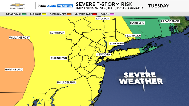
These storms may contain damaging winds, large hail and torrential downpours.
The New York City Emergency Management Department issued a weather alert and activated the city's Flash Flood Emergency Plan.
"This proactive approach includes pre-storm actions such as targeted inspection and clearing of catch basins in flood-prone areas," a news release stated.
How much rain to expect
The flood risk will again be on the higher side. The saturated airmass that will be in place will allow for prolific rainfall rates at times, reaching 1-2 inches per hour, which would most definitely lead to flash flooding. Saturated ground leftover from Saturday's violent storms will only exacerbate the flood threat.
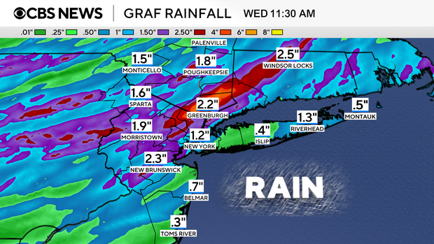
After 11 p.m., storm activity will start to settle down, but there may be another round of storms on Wednesday. Overall, this upcoming rainfall event will likely put down 1-2 inches of rain on average. Localized higher amounts are possible as well.


