Mild Wednesday in Minnesota ahead of more precipitation, arctic cold


Minnesota, get ready for an extremely complicated 48 hours of weather.
Wednesday will be dry and mild in the Twin Cities with highs in the 30s. There is a possibility of patchy drizzle in parts.

Rain showers will arrive on Wednesday evening and continue through the overnight hours as temperatures remain in the upper 30s by daybreak.
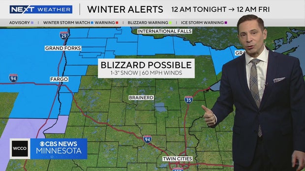
A winter storm watch is in effect along and south of the Canadian border for up to 5-8 inches of blowing snow. The watch will likely be upgraded to a blizzard warning later Wednesday.
An arctic cold front Thursday will drop temperatures from near 40 before sunrise to the 10s by dinnertime. Also expect off-and-on snow showers Thursday, with an inch or less of accumulation.
Roads may freeze over by Thursday evening's commute, and could remain slippery through Friday morning's rush hour.

Friday will be cloudy, starting near or below zero, with wind chills in the minus 10s to minus 20s. Highs will eventually rise into the low 20s.
A dusting of snow is possible Friday night and early Saturday, but it will be a dry weekend with quite a bit of sun. Saturday will be the milder day with highs in the upper 20s. Sunday's highs will drop into the 10s.
Highs hover near freezing through next week and beyond, which is above average for this time of year.
No big storms are expected next week, making for good local holiday travel conditions.